Stonehenge Decoded
| Stonehenge, Avebury and Associated Sites | |
|---|---|
| Name as inscribed on the World Heritage List | |
 |
|
| Location | United Kingdom |
| Type | Cultural |
| Criteria | i, ii, iii |
| Reference | 373 |
| UNESCO region | Europe and North America |
| Coordinates | 51°10′44″N 1°49′34″W / 51.178844°N 1.826189°WCoordinates: 51°10′44″N 1°49′34″W / 51.178844°N 1.826189°W |
| Inscription history | |
| Inscription | 1986 (10th Session) |
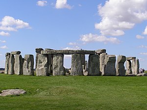
The prehistoric monument of Stonehenge has long been studied for its possible connections with ancient astronomy. The site is aligned in the direction of the sunrise of the summer solstice and the sunset of the winter solstice. Archaeoastronomers have made a range of further claims about the site’s connection to astronomy, its meaning, and its use.
Stonehenge has an opening in the henge earthwork facing northeast, and suggestions that particular significance was placed by its builders on the solstice and equinox points have followed. For example, the summer solstice sun rose close to the Heel Stone, and the sun’s first rays shone into the centre of the monument between the horseshoe arrangement. While it is possible that such an alignment could be coincidental, this astronomical orientation had been acknowledged since William Stukeley drew the site and first identified its axis along the midsummer sunrise in 1720.
Stukeley noticed that the Heel Stone was not precisely aligned on the sunrise. The drifting of the position of the sunrise due to the precession of the equinoxes since the monument’s erection does not account for this imprecision. Recently, evidence has been found for a neighbour to the Heel Stone, no longer extant. The second stone may have instead been one side of a ‘solar corridor’ used to frame the sunrise.
Stukeley and the renowned astronomer Edmund Halley attempted what amounted to the first scientific attempt to date a prehistoric monument. Stukeley concluded the Stonehenge had been set up “by the use of a magnetic compass to lay out the works, the needle varying so much, at that time, from true north.” He attempted to calculate the change in magnetic variation between the observed and theoretical (ideal) Stonehenge sunrise, which he imagined would relate to the date of construction. Their calculations returned three dates, the earliest of which, 460 BC, was accepted by Stukeley. That was incorrect, but this early exercise in dating is a landmark in field archaeology.
Early efforts to date Stonehenge exploited changes in astronomical declinations and led to efforts such as H. Broome’s 1864 theory that the monument was built in 977 BC, when the star Sirius would have risen over Stonehenge’s Avenue. Sir Norman Lockyer proposed a date of 1680 BC based entirely on an incorrect sunrise azimuth for the Avenue, aligning it on a nearby Ordnance Survey trig point, a modern feature. Petrie preferred a later date of 730 AD. The relevant stones were leaning considerably during his survey, and it was not considered accurate.
...
Wikipedia

