Stokesdale, North Carolina
| Stokesdale, North Carolina | ||
|---|---|---|
| Town | ||
|
||
| Motto: "Armor Vincit Omnia" | ||
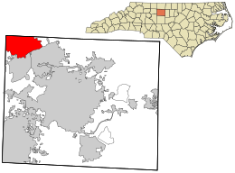
 Location in Guilford County and the state of North Carolina. |
||
| Coordinates: 36°14′11″N 79°58′57″W / 36.23639°N 79.98250°WCoordinates: 36°14′11″N 79°58′57″W / 36.23639°N 79.98250°W | ||
| Country | United States | |
| State | North Carolina | |
| County | Guilford | |
| Area | ||
| • Total | 19.5 sq mi (50.5 km2) | |
| • Land | 19.4 sq mi (50.2 km2) | |
| • Water | 0.1 sq mi (0.3 km2) | |
| Elevation | 945 ft (288 m) | |
| Population (2010) | ||
| • Total | 5,047 | |
| • Density | 168.5/sq mi (65.1/km2) | |
| Time zone | Eastern (EST) (UTC-5) | |
| • Summer (DST) | EDT (UTC-4) | |
| ZIP code | 27357 | |
| Area code(s) | 336 | |
| FIPS code | 37-65040 | |
| GNIS feature ID | 1022797 | |
| Website | www.stokesdale.org | |
Stokesdale is a town in the northwestern corner of Guilford County, North Carolina, United States. The population was 3,267 at the 2000 census. At the 2010 census, the population had risen to 5,047. Belews Lake is located nearby.
Stokesdale is located at 36°14′11″N 79°58′57″W / 36.23639°N 79.98250°W (36.236371, -79.982393).
According to the United States Census Bureau, the town has a total area of 19.5 square miles (51 km2), of which, 19.4 square miles (50 km2) of it is land and 0.1 square miles (0.26 km2) of it (0.56%) is water.
As of the census of 2010, there were 5,047 people, 1,201 households, and 962 families residing in the town. The population density was 168.5 people per square mile (65.1/km²). There were 1,268 housing units at an average density of 65.4 per square mile (25.3/km²). The racial makeup of the town was 90.69% White, 6.95% African American, 0.31% Native American, 0.67% Asian, 0.46% from other races, and 0.92% from two or more races. Hispanic or Latino of any race were 1.93% of the population.
...
Wikipedia

