St Johns Wood, Queensland
|
St Johns Wood Brisbane, Queensland |
|||||||||||||
|---|---|---|---|---|---|---|---|---|---|---|---|---|---|

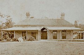
Granite House, St. John's Wood 1880
|
|||||||||||||
| Coordinates | 27°26′53.96″S 152°58′32.29″E / 27.4483222°S 152.9756361°ECoordinates: 27°26′53.96″S 152°58′32.29″E / 27.4483222°S 152.9756361°E | ||||||||||||
| Established | 1858 | ||||||||||||
| Postcode(s) | 4060 | ||||||||||||
| Time zone | AEST (UTC+10) | ||||||||||||
| Location | 6 km (4 mi) NW of Brisbane | ||||||||||||
| LGA(s) | City of Brisbane, The Gap Ward | ||||||||||||
| Region | South East Queensland | ||||||||||||
| County | Stanley | ||||||||||||
| Parish | Enoggera | ||||||||||||
| State electorate(s) | Ashgrove | ||||||||||||
| Federal Division(s) | Brisbane | ||||||||||||
|
|||||||||||||
St Johns Wood is a locality within the suburb of Ashgrove in Brisbane, Australia. A small residential pocket at the base of Taylor Range, it is embraced by a loop of Enoggera Creek and by the Ashgrove Golf Club, Brisbane City Council Reserve and the Enoggera Barracks. The locality was originally inhabited by the Indigenous Turrbal people before it opened up to European settlement during the second land-sales of the district in 1858, with the homestead called St John's Wood House (also known as Granite House) founded in 1864. It remains and occupies a small parcel of land within the locality, with the remainder being subdivided into housing allotments. Additionally, it is home to St Johns Wood Scout Group and The Woods Early Education Centre & Pre-school. The neighbourhood is accessed by either vehicular bridge, bikepath or footbridge. A prominent controversy for St Johns Wood surrounds the question of whether Princes Albert and George visited St Johns Wood on their visit to Brisbane in 1881.
The St Johns Wood and wider area (Ashgrove's native name is "Kallindarbin") was originally inhabited by the indigenous Turrbal or "Duke of York" clan. The main thoroughfare, Waterworks Road, was built on a Turrbal pathway that led to Mount Coot-tha, a place of the "Honey-Bee Dreaming". The water holes along Enoggera Creek and its tributaries, with their dense fringing scrubs, met many of the needs of a hunter-gatherer society. With its rainforests, eucalypt forests and connection to the Brisbane River, it would have provided a source of freshwater and food for the Turrbal people. The rainforests yielded yams, black beans and wild figs, all of which still grow along the creek today. Everyday life for the tribe consisted of hunting and gathering food, with time for games, and other social and spiritual activities. Inevitably with the expansion of European influence the balance of land use changed and this led to the eventual displacement of the Turrbal from their traditional base.
The first Europeans were presented with well watered alluvial flats along Enoggera Creek, partly covered with scrub and presumably seen to include land suitable for cultivation. The land beyond the creek flats and in the foothills of the Taylor Range had better soil derived from the granite and was suitable for grazing. These were the factors that set the pattern for the sale of firstly leasehold and then freehold land by the crown in the pre-separation period.
...
Wikipedia

