St John the Baptist Church, Uddingston
Uddingston
|
|
|---|---|
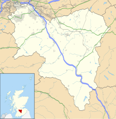
| Uddingston shown within South Lanarkshire | |
| Population | 5,000 |
| OS grid reference | NS696603 |
| Council area | |
| Lieutenancy area | |
| Country | Scotland |
| Sovereign state | United Kingdom |
| Post town | Glasgow |
| Postcode district | G71 7 |
| Dialling code | 01698 |
| Police | Scottish |
| Fire | Scottish |
| Ambulance | Scottish |
| EU Parliament | Scotland |
| UK Parliament | |
| Scottish Parliament | |
Uddingston (Scots: Uddinstoun, Scottish Gaelic: Baile Udain) is a small town in South Lanarkshire, Scotland. It is on the north side of the River Clyde, about 7 miles (11 km) south-east of Glasgow city centre. Uddingston acts as a dormitory suburb for the city.
Uddingston is a village in South Lanarkshire and outside of Glasgow, located 7 miles (11 km) to the south-east of the city centre and approximately 2 miles (3 km) east of the Glasgow City Council boundary (ending at the former Glasgow Zoo). It is bounded to the south-west by the River Clyde as it flows north-west through Glasgow and separates Uddingston, along with some woodland, from Blantyre and Cambuslang. As such, the Clyde Walkway and National Cycle Route 75 both traverse the town. The nearest settlement to Uddingston is the village of Bothwell, 2 miles (3 km) to the south-east.
The village of Uddingston, which is contained exclusively within the boundaries of South Lanarkshire Council, houses around 5,000 residents. However, the nearby North Lanarkshire Council villages of Tannochside, Calderbraes, Viewpark, Birkenshaw and Spindlehowe form a continuous conurbation with Uddingston and are considered districts of Uddingston. As a result, the population of this larger manifestation of Uddingston is approximately 25,000 residents. "Greater Uddingston" shares a boundary with the nearby town of Bellshill (the town centres are 3 miles [5 km] apart), is 4 miles (6 km) south of Coatbridge and via Bothwell 4 1⁄2 miles (7 km) north-west of Hamilton.
...
Wikipedia

