St Helier
| Saint Helier | |||
|---|---|---|---|
| Jersey parish | |||

St Helier viewed across the Old Harbour
|
|||
|
|||
|
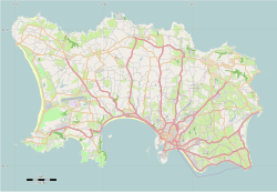
Location of Saint Helier Saint-Hélier in Jersey |
|||
| Coordinates: 49°11′13″N 2°06′25″W / 49.187°N 2.107°WCoordinates: 49°11′13″N 2°06′25″W / 49.187°N 2.107°W | |||
| Crown Dependency | Jersey, Channel Islands | ||
| Government | |||
| • Connétable | Simon Crowcroft | ||
| Area | |||
| • Total | 10.6 km2 (4.1 sq mi) | ||
| Area rank | Ranked 5th | ||
| Population (2011) | |||
| • Total | 33,500 | ||
| • Density | 3,200/km2 (8,200/sq mi) | ||
| Time zone | GMT | ||
| • Summer (DST) | UTC+01 (UTC) | ||
| Postcode district | JE2 | ||
| Postcode sector | 3 and 4 | ||
| Website | www.sthelier.je | ||
Saint Helier (/sintˈhɛliər/) is one of the twelve parishes of Jersey, the largest of the Channel Islands in the English Channel. St Helier has a population of about 33,500, roughly 34.2% of the total population of Jersey, and is the capital of the Island (although Government House is situated in St Saviour). The urban area of the parish of St Helier makes up most of the largest town in Jersey, although some of the town area is situated in adjacent St Saviour, with suburbs sprawling into St Lawrence and St Clement. The greater part of St Helier is rural.
The parish covers a surface area of 4.1 square miles (10.6 km2), being 9% of the total land area of the Island (this includes reclaimed land area of 494 acres (2.00 km2) or 200 ha).
The parish arms are two crossed gold axes on a blue background, the blue symbolising the sea, and the axes symbolising the martyrdom of Helier at the hands of Saxon pirates in 555 AD.
It is thought that the site of St Helier was settled at the time of the Roman control of Gaul.
The medieval hagiographies of Helier, the patron saint martyred in Jersey and after whom the parish and town are named, suggest a picture of a small fishing village on the dunes between the marshy land behind and the high-water mark.
...
Wikipedia


