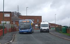
St Ann's, Nottingham
| St Ann's | |
|---|---|
 The St Ann's bus on Brewster Road |
|
| St Ann's shown within Nottinghamshire | |
| Population | 19,316 (Ward 2011) |
| District | |
| Shire county | |
| Region | |
| Country | England |
| Sovereign state | United Kingdom |
| Post town | NOTTINGHAM |
| Postcode district | NG3 |
| Dialling code | 0115 |
| Police | Nottinghamshire |
| Fire | Nottinghamshire |
| Ambulance | East Midlands |
| EU Parliament | East Midlands |
| UK Parliament | |
| St Ann's | |
|---|---|

Vista over Nottingham. (2016)
|
|
| Location | Nottingham, UK |
| Status | Stable |
| Area | 1,068 acres (432 ha) |
| Population (2005) | 15000 |
| Construction | |
| Contractors | Wimpey |
| Authority | City of Nottingham |
| Style | Radburn |
St Ann's is an area of Nottingham, England, with a population that was around 15,000 people according to 2005 figures, increasing to 19,316 at the 2011 census.
The Oswell was a cold water well with alleged magical powers that could cure sore eyes. In 1500, the name changed to honour St Ann, whose cult was ascendant at the time. St Ann was the patron saint of lacemakers, pregnancy and women who had difficulty in conceiving. Water from the well fed a beck (stream) that ran through "The Spring" to the river. There are several ancient names attached to area Peas Hill (1230), Hunger Hills (1304) and Clay Fields.
In the 1750s Charles Morley started manufacturing brown earthenware, specialising in beer mugs.
In the 1830s Clay fields was divided into plots. With The Enclosure Act of 1845 allowed the city to take 1,068 acres (432 ha) of the Clay fields. It was used for housing, and by 1880 the build of 'New Town' was complete. It was specifically built for the working poor. They were very basic cottages, with a butcher, a baker, a large number of public houses, a market place and, for the first time in Britain, allotments where the poor could grow their vegetables. The Public Health Act 1875 enabled local authorities to make byelaws to regulate such building. Here all the houses were pre-Public Health Act terraced houses, on a gridiron plan arranged around courts of ten houses. These were later demolished under slum-clearance legislation of the 1960s.
The estate was a town within a town, the local constabulary refused to enter St Ann's estate, so policing was managed by the residents relying on 'family affiliation'. It was an area of hard work and low pay that culturally was separate from Nottingham. But it was an area of 10,000 houses where only 9% had an inside toilet, and 50% had no hot water system- many of the yards had shared toilets and open sewers leading to dysentry and cholera. Infant mortality was three times the national average. The latest immigrants, and in 1968 that meant West Indians and Jamaican in particular, had been allocated the worst housing. Clearances of houses such as these started in 1930, but because of the war 'New Town' continued until 1970. The houses were flattened and the residents dispersed.
...
Wikipedia

