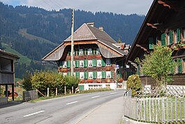
St. Stephan BE
| St. Stephan | ||
|---|---|---|

St. Stephan village
|
||
|
||
| Coordinates: 46°30′N 7°23′E / 46.500°N 7.383°ECoordinates: 46°30′N 7°23′E / 46.500°N 7.383°E | ||
| Country | Switzerland | |
| Canton | Bern | |
| District | Obersimmental-Saanen | |
| Government | ||
| • Mayor | Hans Grünenwald | |
| Area | ||
| • Total | 60.9 km2 (23.5 sq mi) | |
| Elevation | 1,008 m (3,307 ft) | |
| Population (Dec 2015) | ||
| • Total | 1,340 | |
| • Density | 22/km2 (57/sq mi) | |
| Postal code | 3772 | |
| SFOS number | 0793 | |
| Surrounded by | Zweisimmen, Diemtigen, Adelboden, Lenk and Saanen | |
| Website |
www SFSO statistics |
|
St. Stephan is a municipality in the Obersimmental-Saanen administrative district in the canton of Bern in Switzerland. The namesake is the First Century martyr.
St. Stephan is first mentioned in 1352 as Sant Stephan.
The village grew out of a Burgundian royal estate located in a pass to Valais. In 994 it the royal family donated St. Stephan to Selz Abbey. Eventually the village became part of the lands of the Freiherr of Raron. In 1456 it passed to the Bubenberg family and then in 1494 was acquired by the city of Bern.
The village church of St. Stephan was built in the Early Middle Ages. The original building was renovated and expanded in the 12th and 15th centuries. It was originally a filial church of the parish church in Zweisimmen. In 1335 Interlaken Abbey took over the patronage of St. Stephan. In the 15th century the residents began attempting to break away from the Abbey and form their own parish. Despite authorization from the Pope in 1430 and a decision of the Council of Basel in 1433, the Abbey remained in control. Finally, in 1525, the villagers were released from the Abbey's patronage and formed their own parish. Three years later, in 1528, Bern adopted the new faith of the Protestant Reformation. Interlaken Abbey and majority of the Bernese Oberland resisted the new faith. However, in the same year, Bern forced the Oberland, including St. Stephan, to convert.
...
Wikipedia


