St. Elmo, Colorado
|
St. Elmo Historic District
|
|

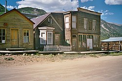
Buildings along Main Street
|
|
| Location | Pitkin, Gunnison, 1st., Main and Poplar Sts., St. Elmo, Colorado |
|---|---|
| Coordinates | 38°42′17″N 106°20′42″W / 38.70472°N 106.34500°WCoordinates: 38°42′17″N 106°20′42″W / 38.70472°N 106.34500°W |
| Area | 70 acres (28 ha) |
| NRHP Reference # | 79000577 |
| CSRHP # | 5CF.139 |
| Added to NRHP | September 17, 1979 |
St. Elmo is a ghost town in Chaffee County, Colorado, United States. Founded in 1880, St. Elmo lies in the heart of the Sawatch Range, 20 miles (32 km) southwest of Buena Vista and sits at an elevation of 9,961 feet (3,036 m). Nearly 2,000 people settled in this town when mining for gold and silver started. The mining industry started to decline in the early 1920s, and in 1922 the railroad discontinued service. The community is listed on the National Register of Historic Places as the St. Elmo Historic District. It is one of Colorado's best preserved ghost towns.
St. Elmo was originally named Forest City but was later changed because of the multitude of towns with the same name. The name St. Elmo was chosen by Griffith Evans, one of the founding fathers, who was reading a novel with the same title.
The town was at its peak in the 1890s, when it included a telegraph office, general store, town hall, 5 hotels, saloons, dancing halls, a newspaper office, and a school house. The Denver, South Park and Pacific Railroad line ran through St. Elmo. There were 150 patented mine claims within the area. The majority of the people who lived in St. Elmo worked at the Mary Murphy, Teresa C., The Molly or the Pioneer Mines. The Mary Murphy Mine was the largest and most successful mine in the area. The Mary Murphy Mine recovered over $60,000,000 worth of gold while it was in operation. While the other mines eventually shut down, the Mary Murphy Mine continued to operate until the railroad was abandoned in 1922.
...
Wikipedia


