St. Catherines Island
|
St. Catherine's Island
|
|

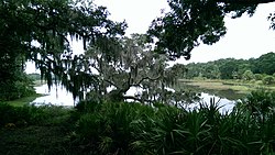
Salt marsh on the island
|
|
| Nearest city | South Newport, Georgia |
|---|---|
| Coordinates | 31°37′50″N 81°9′36.5″W / 31.63056°N 81.160139°WCoordinates: 31°37′50″N 81°9′36.5″W / 31.63056°N 81.160139°W |
| Area | 22,265 acres (90.10 km2) |
| Built | 1566 |
| Architect | Multiple |
| NRHP Reference # | 69000332 |
| Significant dates | |
| Added to NRHP | December 16, 1969 |
| Designated NHLD | December 16, 1969 |
St. Catherines Island is one of the Sea Islands or Golden Isles on the coast of the U.S. state of Georgia, 50 miles (80 km) south of Savannah in Liberty County. The island is ten miles (16 km) long and from one to three miles (5 km) wide, located between St. Catherine's Sound and Sapelo Sound. More than half of its 14,640 acres (59 km²) are tidal marsh and wetlands. About half of it is salt marshes, about a quarter is wooded, and it has "fine" beaches. It is owned by the Saint Catherines Island Foundation is not open to the public, aside from the beach below the high tide line.
The island has been inhabited for at least 4000 years, and was a Guale settlement by 1576. It was the site of the first Spanish outpost in Georgia. By 1587 it was the northernmost permanent Spanish outpost on the Atlantic Coast. Spanish colonies were planted as far north as Chesapeake Bay, but none lasted more than a year or two. During the 17th century, the mission of Santa Catalina de Guale, located on the island from 1602 to 1680, was the center of the Guale missionary province of Spanish Florida. David Hurst Thomas has focused on Spanish period mission archaeology on St. Catherine's Island. Currently, archaeology of the shell ring on St. Catherines Island is spearheaded by David Hurst Thomas and Matthew C. Sanger.
In 1766 the island was leased by Button Gwinnett, a signer of the Declaration of Independence. It was run as a plantation for nearly a century, until the Civil War ended. The New Georgia Encyclopedia notes that
...
Wikipedia


