St. Agnes, Isles of Scilly
St. Agnes
|
|
|---|---|
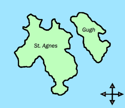
 A map of St. Agnes with Gugh to the east. |
|
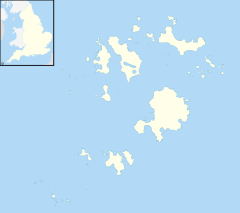
| St. Agnes shown within Isles of Scilly | |
| Population | 82 (2011) |
| OS grid reference | SV881430 |
| Civil parish |
|
| Unitary authority | |
| Ceremonial county | |
| Region | |
| Country | England |
| Sovereign state | United Kingdom |
| Post town | ISLES OF SCILLY |
| Postcode district | TR22 |
| Dialling code | 01720 |
| Police | Devon and Cornwall |
| Fire | Isles of Scilly |
| Ambulance | South Western |
| EU Parliament | South West England |
| UK Parliament | |
St Agnes (Cornish: Aganas ) is the southernmost populated island of the Isles of Scilly — Troy Town Farm on the island is the southernmost settlement in the United Kingdom and England.
St Agnes joins the island of Gugh by a tombolo, a kind of sandbar, called the Gugh Bar, which is exposed only at low tide. The Gugh is inhabited, with some three residents. The two islands of St Agnes and Gugh together have a population of 85 residents recorded in the 2011 census (73 were recorded in the 2001 census) and a landmass of 366 acres (148 ha). Without the Gugh included, St Agnes is marginally smaller than Bryher in either population or area; however if Gugh is included with St Agnes, it is Bryher that is marginally smaller in area and population.
In earlier times many men from St Agnes earned a living as pilots, guiding transatlantic liners and other vessels through the English Channel. Now the mainstay of the economy is tourism, together with some bulb farming. Accommodation is limited, and St Agnes is the only populated island in the Isles of Scilly which has no hotel. However, it has a few B&Bs and self-catering cottages, an ice cream shop, a campsite, a small post office & general store and a gift shop. It also has a pub (the Turk's Head) and a cafe, although these are closed in the winter.
The main population centre is in the north and middle of the island. The southern end of the island is covered by the heather moorland of Wingletang Down.
The island's most notable landmark is its lighthouse, which has been converted into living accommodation and the tower no longer contains a light. In 1680 Trinity House began a survey of the coasts of England as it was known that the contemporary charts were inaccurate; the Isles of Scilly was plotted ten miles to the north. Trinity House was also given permission to erect and maintain one or more lighthouses on the islands. St Agnes was chosen as it is the most westerly of the inhabitable islands and close to the collection of rocks, tidal flows and currents, now known as the Western Rocks. It was built in 1680 and was coal fired until 1790, when it was converted to oil, with copper lamps and twenty-one revolving reflectors. A plaque records the original construction by Captains Hugh Hill and Simon Bayly, builders of the 1676 Lowestoft lighthouse. There were two protests against the building of the St Agnes light. Officials from the Isle of Wight complained that they would lose revenue from harbour dues and victualling as shipping would prefer to use the Isles of Scilly, and the Governor of Scilly on the grounds that he would lose money from wrecks!
...
Wikipedia

