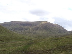
Sròn a' Choire Ghairbh
| Sròn a’ Choire Ghairbh | |
|---|---|

The western slopes of Sròn a‘ Choire Ghairbh seen from the head of Gleann Cia-aig. The Cam Beallach is seen on the right hand side.
|
|
| Highest point | |
| Elevation | 937 m (3,074 ft) |
| Prominence | 622 m (2,041 ft) |
| Parent peak | Sgurr na Ciche |
| Listing | Munro, Marilyn |
| Naming | |
| Translation | Nose of the Rough Corrie (Gaelic) |
| Pronunciation | Scottish Gaelic: [ˈs̪t̪ɾɔːn ə ˈxɔɾʲə ˈɣɛɾʲɛv] English approx: straun uh khor-yuh gherr-yev |
| Geography | |
| Location | Highland, Scotland |
| Parent range | Northwest Highlands |
| OS grid | NN222946 |
| Topo map | OS Landranger 34, OS Explorer 400 |
Sròn a’ Choire Ghairbh is a Scottish mountain situated on the northern side of Loch Lochy, 13 kilometres north of Spean Bridge in the Highland Council area.
Sròn a’ Choire Ghairbh reaches a height of 937 metres (3074 feet) and is classified as both a Munro and a Marilyn. It is highest of the Loch Lochy hills and is invariably climbed along with the neighbouring Munro of Meall na Teanga to which it is joined by the distinctive col of the Cam Bhealach. Both these hills which are often referred to as the Loch Lochy Munros are well seen from the A82 road on the opposite side of the loch, showing steep slopes which are forested below the 300 metre contour. There are also extensive conifer plantings on the lower northern (Glen Garry) side of the mountain, this is gradually being restored to native species. The hills name translates from the Gaelic as The Nose of the Rough Corrie referring to the summits location on the edge of the craggy Coire Glas, which stands to the east.
Sròn a’ Choire Ghairbh’s main geographical feature is the Coire Glas which has the small Loch a’ Choire Ghlais within its upper recesses. The mountain is horse shoe shaped and throws down two ridges on either side of the corrie, the lengthy east ridge is five kilometres long and goes over the two subsidiary tops of Sean Mheall (888 metres) and Meall nan Dearcag (693 metres) before descending to the Kilfinnan Burn at the north end of Loch Lochy. Another ridge called Meall a’ Choire Ghlais goes north and then north east along the other side of Corrie Glas, it loses very little height for two kilometres before descending steeply and rockily to the Beallach Easain (548 metres) which connects it to the Corbett Ben Tee.
In all other directions the mountain is steep and grassy, to the south lies the Cam Beallach, a mountain pass that links to the Munro Meall na Teanga, the Cam Beallach is seen as a distinct notch in the skyline between the two Munros whether viewed from the east or the west. To the north is the small Coire an Eich which drains north into Glen Garry to find its way to the sea at the east coast via Loch Ness. Sròn a’ Choire Ghairbh is actually on the main north-south water divide of Scotland with rainfall on all other parts of the hill going to the west coast via Loch Lochy and Loch Linnhe.
...
Wikipedia
