Squak Mountain
| Squak Mountain | |
|---|---|

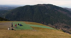
Squak Mountain (Southeast and Central Peaks) as seen from Poo Poo Point (east)
|
|
| Highest point | |
| Elevation | 2,028 ft (618 m) |
| Prominence | 1,689 ft (515 m) |
| Coordinates | 47°29′47″N 122°02′18″W / 47.49639°N 122.03833°W |
| Geography | |
| Location | King County, Washington, U.S. |
| Parent range | Issaquah Alps |
Squak Mountain is the second most westerly mountain of the Issaquah Alps mountain chain in Washington state. It is situated between Cougar Mountain to the west and Tiger Mountain to the east. Interstate 90 parallels the base of the north side of the mountain. Much of the Squak Mountain watershed drains into Lake Sammamish. Most of the mountain is protected by Squak Mountain State Park and Cougar/Squak and Squak/Tiger Corridors of King County.
Squak Mountain actually consists of three major peaks: the Central Peak (Elevation 2024 feet), the West Peak (Elevation 1995 feet), and the Southeast Peak (Elevation 1673 feet).
The name "Squak" comes from the Southern Lushootseed placename /sqʷásxʷ/, which is also the source of the name Issaquah Creek and the city of Issaquah.
Squak Mountain first appears in the history of European settlement after the discovery of coal on the mountain in 1859. This helped fuel the establishment of the first commercial coal mine in Issaquah, WA in 1862 and in Renton, WA in 1863. While there is no longer coal mining on Squak Mountain, the dangers posed by abandoned mines are one reason it has been preserved from development.
Squak Mountain State Park was formed in 1972. The initial land grant of 590 acres to form the park was made by the Bullitt family. The initial grant was near the top and specified that the land remain in its natural state. These stipulations can still be seen today in the greater restrictions in park usage at the top of the mountain, on the original Bullitt family parcel. The remains of the Bullitt family home (just a foundation and fireplace) can be found in this original parcel.
...
Wikipedia
