Springfield, South Carolina
| Springfield, South Carolina | |
|---|---|
| Town | |
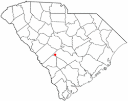
 Location of Springfield, South Carolina |
|
| Coordinates: 33°29′45″N 81°16′45″W / 33.49583°N 81.27917°WCoordinates: 33°29′45″N 81°16′45″W / 33.49583°N 81.27917°W | |
| Country | United States |
| State | South Carolina |
| County | Orangeburg |
| Area | |
| • Total | 1.6 sq mi (4.0 km2) |
| • Land | 1.6 sq mi (4.0 km2) |
| • Water | 0.0 sq mi (0.0 km2) |
| Elevation | 302 ft (92 m) |
| Population (2000) | |
| • Total | 504 |
| • Density | 322.8/sq mi (124.6/km2) |
| Time zone | Eastern (EST) (UTC-5) |
| • Summer (DST) | EDT (UTC-4) |
| ZIP code | 29146 |
| Area code(s) | 803 |
| FIPS code | 45-68470 |
| GNIS feature ID | 1226837 |
Springfield is a town in Orangeburg County, South Carolina, United States. The population was 504 at the 2000 census.
The Springfield High School was added to the National Register of Historic Places in 2001.
Springfield is located at 33°29′45″N 81°16′45″W / 33.49583°N 81.27917°W (33.495818, -81.279294).
According to the United States Census Bureau, the town has a total area of 1.6 square miles (4.0 km²), all of it land.
The town has also hosted the SC Governor's Frog Jump since 1969.
There is also a livestock auction and flea market, venues that are unique for the area.
As of the census of 2000, there were 504 people, 228 households, and 152 families residing in the town. The population density was 322.8 people per square mile (124.7/km²). There were 263 housing units at an average density of 168.4 per square mile (65.1/km²). The racial makeup of the town was 69.84% White, 29.37% African American, 0.60% Native American and 0.20% Asian. Hispanic or Latino of any race were 0.79% of the population.
...
Wikipedia
