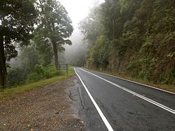
Springbrook Road
| Springbrook Road | |
|---|---|

2016
|
|
| Location | Springbrook-Mudgeeraba Road, Springbrook, Queensland, Australia |
| Coordinates | 28°08′14″S 153°16′43″E / 28.1373°S 153.2787°ECoordinates: 28°08′14″S 153°16′43″E / 28.1373°S 153.2787°E |
| Design period | 1919 - 1930s (interwar period) |
| Built | 1925 - 1928 |
| Official name: Springbrook Road and Associated Infrastructure, Memorial Cairn, Springbrook Mudgeeraba Road, Toll Road | |
| Type | state heritage (built) |
| Designated | 22 October 1999 |
| Reference no. | 602140 |
| Significant period | 1920s (fabric) |
| Significant components | cutting - road, plaque, lookout/observation platform, trough - drinking, bridge/viaduct - road, memorial - cairn, fountain |
Springbrook Road is a heritage-listed road at Springbrook-Mudgeeraba Road, Springbrook, Queensland, Australia. It was built from 1925 to 1928. It is also known as Memorial Cairn, Springbrook-Mudgeeraba Road, and Toll Road. It was added to the Queensland Heritage Register on 22 October 1999.
The Springbrook-Mudgeeraba Road was constructed to encourage settlement and development in the Springbrook area in the mid 1920s. Several elements including two curved timber bridges, a water trough and a water fountain date from this early construction time.
The difficulty of access to the Springbrook plateau was a significant factor in the delay of settlement. Prior to settlement in 1906, the only access consisted of a walking trail on the western side that ended up in the Numinbah Valley. Once land was advertised for selection, the Queensland Lands Department was required to provide a road.
The early settlers knew that for their farms to succeed, reliable access was necessary. The determination to provide an alternate route off the mountain resulted in two tracks being brushed through the forest. One headed off the southern end of the plateau towards the village of Mudgeeraba. Jim Hardy and George Trapp blazed the Mudgeeraba track by following the ridge that separates the east and west branches of Little Nerang Creek. When they reached the confluence of the two creeks they turned east, only to find that the Nimmel Range blocked their way. By skirting round the flanks of Mount Nimmel, they managed to reach the dirt track that linked Mudgeeraba with the little cluster of farms near Neranwood.
By 1914 the track was upgraded to allow horse-drawn wagons known as "buckboards" to negotiate the rough terrain. It coiled its way off the mountain down present-day Carrick Road and beyond to the meeting of the east of west branches of the Little Nerang Creek, over the Mount Nimmel Range and on through the Alstonville Valley before joining the present road at the Alstonville turn-off. The first Springbrook to Mudgeeraba road was an improvement on the brushed track.
After several deputations in the 1920s to the Minister for Main Roads, it was decided to survey a new route onto the mountain. The gradient required for such an undertaking was of much concern to the surveyors. A gradient of 1 in 18 was considered to be the limit for successful road building in Queensland at the time. The deputations from the Springbrook residents must have been very persuasive as the proposed Springbrook road required a gradient of 1 in 12 and in parts 1 in 10. It is believed to be the first road in Queensland to have been successfully constructed using such a steep gradient. A Swiss engineer named Juries was employed to conduct the initial survey, due to his experience in mountainous country. Fred Parkes, the Main Roads engineer and Tom Peters who represented the Nerang Shire, were grateful for his expertise. The terrain was so rough and steep that it was necessary to dig toeholds into the sheer hillsides, to enable the men to safely carry the delicate survey instruments to the next position.
...
Wikipedia


