Springboro, Pennsylvania
| Springboro, Pennsylvania | |
|---|---|
| Borough | |

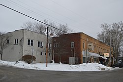
Commercial district at the crossroads
|
|
 Location of Springboro in Crawford County |
|
| Location of Springboro in Pennsylvania | |
| Coordinates: 41°48′0″N 80°22′16″W / 41.80000°N 80.37111°WCoordinates: 41°48′0″N 80°22′16″W / 41.80000°N 80.37111°W | |
| Country | United States |
| State | Pennsylvania |
| County | Crawford County |
| Founded | 1800 |
| Area | |
| • Total | 0.83 sq mi (2.15 km2) |
| • Land | 0.83 sq mi (2.15 km2) |
| • Water | 0.0 sq mi (0.0 km2) |
| Elevation | 940 ft (290 m) |
| Population (2010) | |
| • Total | 477 |
| • Density | 575/sq mi (222.2/km2) |
| Time zone | EST (UTC-4) |
| • Summer (DST) | EDT (UTC-5) |
| Area code(s) | 814 |
Springboro is a borough in Crawford County, Pennsylvania, United States. The population was 477 at the 2010 census.
Incorporated as a borough in the spring of 1866, the crossroads officially became Springboro in 1840. 2015 is the 175th year.
Springboro is located in northwestern Crawford County at 41°48′0″N 80°22′16″W / 41.80000°N 80.37111°W (41.800055, -80.371031). It is surrounded by Spring Township, a separate municipality.
Pennsylvania Route 18 passes through the center of town, leading north 6 miles (10 km) to Albion and south 3 miles (5 km) to Conneautville.
According to the United States Census Bureau, the borough has a total area of 0.83 square miles (2.15 km2), all of it land.Conneaut Creek flows northward through the western side of the borough on its way to Lake Erie.
As of the census of 2000, there were 491 people, 183 households, and 133 families residing in the borough. The population density was 577.5 people per square mile (223.0/km²). There were 208 housing units at an average density of 244.6 per square mile (94.5/km²). The racial makeup of the borough was 96.33% White, 3.46% African American and 0.20% Native American.
...
Wikipedia

