Spring Valley, San Diego, California
| Spring Valley | |
|---|---|
| census-designated place | |
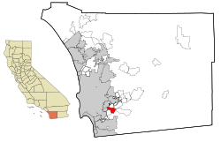
 Location in San Diego County and the state of California |
|
| Coordinates: 32°44′4″N 116°58′53″W / 32.73444°N 116.98139°WCoordinates: 32°44′4″N 116°58′53″W / 32.73444°N 116.98139°W | |
| Country |
|
| State |
|
| County | San Diego |
| Area | |
| • Total | 7.374 sq mi (19.099 km2) |
| • Land | 7.165 sq mi (18.558 km2) |
| • Water | 0.209 sq mi (0.541 km2) 2.83% |
| Elevation | 390 ft (119 m) |
| Population (2010) | |
| • Total | 28,205 |
| • Density | 3,800/sq mi (1,500/km2) |
| Time zone | PST (UTC-8) |
| • Summer (DST) | PDT (UTC-7) |
| ZIP codes | 91976-91979 |
| Area code(s) | 619 |
| FIPS code | 06-73696 |
| GNIS feature ID | 1661495 |
Spring Valley is a census-designated place (CDP) in San Diego County, California. The population was 28,205 at the 2010 census.
The name "Spring Valley" may also refer to a wider area including the Spring Valley CDP, La Presa and part of the neighborhood of Casa de Oro (which extends into La Mesa). There are claims that the "Greater Spring Valley" area has over 100,000 residents.[1]
Spring Valley is served by the 91977 and 91978 ZIP codes.
Spring Valley is named for the natural spring located there. It was long the home of the Kumeyaay people, who called it Neti or Meti. Spanish conquerors drove off the natives and used the area for cattle, calling it El aguaje de San Jorge (St. George's Spring).
In 1863 Judge Augustus S. Ensworth of San Diego filed a claim for a 160-acre (65 ha) ranch that included the spring. The ranch, and the small adobe house he built there, were sold to Rufus King Porter and later to historian Hubert Howe Bancroft. The adobe is now a National Historic Landmark.
The United States Geological Survey (USGS) places Spring Valley at 32°44′41″N 116°59′56″W / 32.74472°N 116.99889°W (32.7447740, -116.9989160). This is near the intersection of Kenwood Drive and Helix Street. Most maps place Spring Valley at this location.
...
Wikipedia

