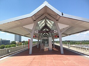
Spring Hill station

Platform of Spring Hill station
|
|||||||||||
| Location | 1576 Spring Hill Road Tysons Corner, Virginia |
||||||||||
| Coordinates | 38°55′45″N 77°14′31″W / 38.92917°N 77.24194°WCoordinates: 38°55′45″N 77°14′31″W / 38.92917°N 77.24194°W | ||||||||||
| Owned by | WMATA | ||||||||||
| Line(s) | |||||||||||
| Platforms | 1 island platform | ||||||||||
| Tracks | 2 | ||||||||||
| Connections |
|
||||||||||
| Construction | |||||||||||
| Structure type | Elevated | ||||||||||
| Other information | |||||||||||
| Station code | N04 | ||||||||||
| History | |||||||||||
| Opened | July 26, 2014 | ||||||||||
| Traffic | |||||||||||
| Passengers (2016) | 1,218 daily |
||||||||||
| Services | |||||||||||
|
|||||||||||
Spring Hill (preliminary names Tysons West, Tysons–Spring Hill Road) is a Washington Metro station in Fairfax County, Virginia, on the Silver Line. Located in Tysons Corner, it began operation on July 26, 2014. The station is located in the central median of Leesburg Pike (SR 7) just west of Spring Hill Road.
There had been some controversy about whether to build the rail through Tysons Corner below ground or on elevated tracks. The efforts to build a tunnel through all of Tysons Corner failed, and the current design has the main platform with a height of 48 ft (15 m) at its east end and 51 ft (16 m) at its west end.
The station is about 5.8 miles (9.3 km) from Wiehle–Reston East, the next station to the west, but only about 0.8 miles (1.3 km) from Greensboro directly to the southeast.
...
Wikipedia
