Spring Hill, Tennessee
| Spring Hill, Tennessee | |
|---|---|
| City | |

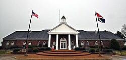
Spring Hill City Hall, December 2013.
|
|
| Motto: "A blend of Commerce, History and Country Living" | |
 Location of Spring Hill, Tennessee |
|
| Coordinates: 35°45′9″N 86°54′50″W / 35.75250°N 86.91389°WCoordinates: 35°45′9″N 86°54′50″W / 35.75250°N 86.91389°W | |
| Country | United States |
| State | Tennessee |
| Counties | Williamson, Maury |
| City | 1808 |
| Government | |
| • Type | City |
| • Mayor | Rick Graham |
| Area | |
| • Total | 17.7 sq mi (45.9 km2) |
| • Land | 17.7 sq mi (45.9 km2) |
| • Water | 0.0 sq mi (0.1 km2) |
| Elevation | 751 ft (229 m) |
| Population (2013) | |
| • Total | 32,576 |
| • Density | 1,640.5/sq mi (633.4/km2) |
| Time zone | Central (CST) (UTC-6) |
| • Summer (DST) | CDT (UTC-5) |
| ZIP code | 37174 |
| Area code(s) | 931 615 |
| FIPS code | 47-70580 |
| GNIS feature ID | 1303764 |
| Website | City of Spring Hill, Tennessee |
| Spring Hill Tennessee's Official Website | |
Spring Hill is a city in Maury and Williamson counties, Tennessee, located approximately 30 miles (48 km) south of Nashville. Spring Hill's population as of 2014 was 34,269.
The first settlers of Spring Hill arrived in 1808 and the city was established in 1809. Albert Russell was the first person to build a home on the land that became Spring Hill.
Spring Hill was the site of a Civil War battle, now known as the Battle of Spring Hill, on November 29, 1864.
Later, Spring Hill was the home of a preparatory school, Branham and Hughes Military Academy, the campus of which now serves as the main campus of Tennessee Children's Home, a ministry associated with the Churches of Christ.
Spring Hill is located at 35°45′9″N 86°54′50″W / 35.75250°N 86.91389°W (35.752556, -86.914021).
According to the United States Census Bureau, the city has a total area of 17.7 square miles (45.9 km²), of which 17.7 square miles (45.9 km²) is land and 0.04 square mile (0.1 km²) (0.17%) is water.
The official main street of Spring Hill is also called US Highway 31, Columbia Pike or Nashville Highway.
As of the 2000 census, there were 7,715 people, 2,634 households and 2,159 families residing in the city. The population density was 435.6 people per square mile (168.2/km²). There were 2,819 housing units at an average density of 159.2 per square mile (61.5/km²). The racial makeup of the city was 88.33% White, 7.80% African American, 0.32% Native American, 0.49% Asian, 0.06% Pacific Islander, 1.81% from other races and 1.17% from two or more races. Hispanic or Latino of any race were 3.98% of the population.
...
Wikipedia
