Split Rock Lighthouse State Park
| Split Rock Lighthouse State Park | |
| Minnesota State Park | |
|
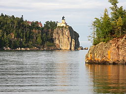
Split Rock Lighthouse State Park seen from the shore of Lake Superior
|
|
| Named for: Split Rock Lighthouse | |
| Country | United States |
|---|---|
| State | Minnesota |
| County | Lake |
| Location | Beaver Bay |
| - elevation | 728 ft (222 m) |
| - coordinates | 47°11′31″N 91°23′34″W / 47.19194°N 91.39278°WCoordinates: 47°11′31″N 91°23′34″W / 47.19194°N 91.39278°W |
| Area | 2,200 acres (890 ha) |
| Founded | 1945 |
| Management | Minnesota Department of Natural Resources |
Split Rock Lighthouse State Park is a state park of Minnesota on the North Shore of Lake Superior. It is best known for the picturesque Split Rock Lighthouse, one of the most photographed lighthouses in the United States. Built by the United States Lighthouse Service in 1910, the lighthouse and some adjacent buildings have been restored and the Minnesota Historical Society operates them as a museum. The 2,200-acre (890 ha) state park offers a unique cart-in campground and scenic trails for hiking, cross-country skiing, and bicycling.
Split Rock Lighthouse State Park encompasses about 4 miles (6.4 km) of rocky shoreline on Lake Superior with several prominent headlands. Named features of the shore, from southwest to northeast, are the mouth of the Split Rock River, Split Rock Point, Crazy Bay, Corundum Point, the mouth of Split Rock Creek, Day Hill, Little Two Harbors, Stony Point (site of the lighthouse), and Gold Rock Point. The name Little Two Harbors comes from the division of the inlet by a small island, formerly a tombolo, and refers to the city of Two Harbors farther down the shore. There are two shallow sea caves at the base of Stony Point.
The east and west branches of the Split Rock River, not to be confused with Split Rock Creek, join in the park. There are ten waterfalls on the river, although because they can only be reached by a moderate hike on the Superior Hiking Trail and are not marked on park maps, they are lightly visited.
Much of the shore of Lake Superior is made of basalt erupted from the Midcontinent Rift System when the middle of the North American Plate began to crack 1.1 billion years ago. In a small tract that includes Split Rock Lighthouse State Park, additional magma intruded into the basalt and cooled underground into a harder rock called diabase. These flows also carried with them blocks of anorthosite, an even harder rock from the base of the Earth's crust, which became interspersed randomly in the diabase. Three large blocks of anorthosite form Corundum Point, Day Hill, and Stony Point beneath the lighthouse. In the southwest portion of the park another eruption formed a layer of red rhyolite. The rhyolite has eroded into several natural pillars, and forms the walls of the Split Rock River gorge.
...
Wikipedia


