Spitsbergen

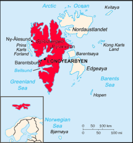
Map of Svalbard with Spitsbergen in the west emphasised
|
|
| Geography | |
|---|---|
| Location | Arctic Ocean |
| Coordinates | 78°45′N 16°00′E / 78.750°N 16.000°ECoordinates: 78°45′N 16°00′E / 78.750°N 16.000°E |
| Archipelago | Svalbard |
| Area | 39,044 km2 (15,075 sq mi) |
| Area rank | 36th |
| Highest elevation | 1,717 m (5,633 ft) |
| Highest point | Newtontoppen |
| Administration | |
|
Norway
|
|
| Largest settlement | Longyearbyen |
| Demographics | |
| Population | 2,642 (2012) |
Spitsbergen (formerly known as West Spitsbergen; Norwegian: Vest Spitsbergen or Vestspitsbergen) is the largest and only permanently populated island of the Svalbard archipelago in northern Norway. Constituting the westernmost bulk of the archipelago, it borders the Arctic Ocean, the Norwegian Sea, and the Greenland Sea. Spitsbergen covers an area of 39,044 km2 (15,075 sq mi), making it the largest island in Norway and the 36th-largest in the world. The administrative centre is Longyearbyen. Other settlements, in addition to research outposts, are the Russian mining community of Barentsburg, the research community of Ny-Ålesund, and the mining outpost of Sveagruva.
The island was first used as a whaling base in the 17th and 18th centuries, after which it was abandoned. Coal mining started at the end of the 19th century and several permanent communities were established. The Svalbard Treaty of 1920 recognized Norwegian sovereignty and established Svalbard as a free economic zone and a demilitarized zone.
The Norwegian Store Norske and the Russian Arktikugol remain the only mining companies. Research and tourism have become important supplementary industries, featuring among others the University Centre in Svalbard and the Svalbard Global Seed Vault. No roads connect the settlements; instead snowmobiles, aircraft, and boats serve as local transport. Svalbard Airport, Longyear provides the main point of entry and exit.
...
Wikipedia
