Spanish conquest of Petén
| Spanish conquest of Petén | |||||||||
|---|---|---|---|---|---|---|---|---|---|
| Part of the Spanish conquest of Guatemala and the Spanish conquest of Yucatán | |||||||||
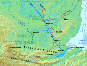
 Spanish entry routes to Petén during the 17th century, overlaid with the route that Hernán Cortés took in 1525 |
|||||||||
|
|||||||||
| Belligerents | |||||||||
| Spanish Empire |
Independent Maya, including:
|
||||||||
| Commanders and leaders | |||||||||
| Martín de Ursúa | Kan Ek' | ||||||||
Independent Maya, including:
The Spanish conquest of Petén was the last stage of the conquest of Guatemala, a prolonged conflict during the Spanish colonisation of the Americas. A wide lowland plain covered with dense rainforest, Petén contains a central drainage basin with a series of lakes and areas of savannah. It is crossed by several ranges of low karstic hills and rises to the south as it nears the Guatemalan Highlands. The conquest of Petén, a region now incorporated into the modern republic of Guatemala, climaxed in 1697 with the capture of Nojpetén, the island capital of the Itza kingdom, by Martín de Ursúa y Arizmendi. With the defeat of the Itza, the last independent and unconquered native kingdom in the Americas fell to European colonisers.
Sizeable Maya populations existed in Petén before the conquest, particularly around the central lakes and along the rivers. Petén was divided into different Maya polities engaged in a complex web of alliances and enmities. The most important groups around the central lakes were the Itza, the Yalain and the Kowoj. Other groups with territories in Petén included the Kejache, the Acala, the Lakandon Ch'ol, the Xocmo, the Chinamita, the Icaiche and the Manche Ch'ol.
Petén was first penetrated by Hernán Cortés with a sizeable expedition that crossed the territory from north to south in 1525. In the first half of the 16th century, Spain established neighbouring colonies in Yucatán to the north and Guatemala to the south. Spanish missionaries laid the groundwork for the extension of colonial administration in the extreme south of Petén from 1596 onwards, but no further Spanish entry of central Petén took place until 1618 and 1619 when missionaries arrived at the Itza capital, having travelled from the Spanish town of Mérida in Yucatán.
...
Wikipedia
