Sowerby, North Yorkshire
| Sowerby | |
|---|---|
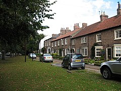
 Front Street Sowerby |
|
| Sowerby shown within North Yorkshire | |
| Population | 4,249 (2011) |
| OS grid reference | SE431810 |
| Civil parish |
|
| District | |
| Shire county | |
| Region | |
| Country | England |
| Sovereign state | United Kingdom |
| Post town | THIRSK |
| Postcode district | YO7 1 |
| Dialling code | 01845 |
| Police | North Yorkshire |
| Fire | North Yorkshire |
| Ambulance | Yorkshire |
| EU Parliament | Yorkshire and the Humber |
| UK Parliament |
|
| Website | http://www.sowerby.org.uk/ |
Sowerby is a small village, electoral ward and civil parish in the Hambleton district of North Yorkshire, England, it is situated immediately south of Thirsk. The parish boundary merges with that of Thirsk, so the village could be described as a suburb. The author James Herriot lived in the village.
The lines of a Roman road can still be seen in the fields to the north and east of the village along the Green Lane and was known as The Saxty Way.
The village is mentioned twice in the Domesday Book as Sorebi in the Yarlestre hundred. The land was split across both the head manors of Easingwold and Newsham. At the time of the Norman invasion, the manors were split between Earl Morcar and Ligulf, who granted land to Orm. Afterwards, the lands became Crown property. The overlordship was granted to the Mowbray family, who granted land to William Lascelles in 1228. The Lascelles family held their manor until 1602, when it was sold to the Meynell family. The manor has followed the inheritance of the manor at North Kilvington since then. William de Vescy of Kildare held a mesne lordship in the area in the 14th century.
The Lascelles (Lassels) family were also credited with building a terrace of houses at the north end of the village, still known as Blue (or Bribery) Terrace, since tenants were expected to vote for the candidate who supported the Tory cause.
Sowerby's name comes from the Norse language, in which it means 'Farmstead (by the) muddy/sour ground', which is the origin of the word sewer.
In the south of the parish, Cod Beck is crossed by a 17th-century pack horse bridge at Blakey Lane, which is a Grade II listed building. Further south, Cod Beck is crossed again on South Moor Lane, by another 17th century pack horse bridge, which is also a Grade II Listed building.
...
Wikipedia

