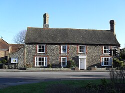
Southwick, West Sussex
| Southwick | |
|---|---|
 |
|
| Southwick shown within West Sussex | |
| Area | 3.33 sq mi (8.6 km2) |
| Population | 13,195 2001 Census |
| • Density | 3,962/sq mi (1,530/km2) |
| OS grid reference | TQ241055 |
| • London | 46 miles (74 km) N |
| District | |
| Shire county | |
| Region | |
| Country | England |
| Sovereign state | United Kingdom |
| Post town | BRIGHTON |
| Postcode district | BN42 |
| Dialling code | 01273 |
| Police | Sussex |
| Fire | West Sussex |
| Ambulance | South East Coast |
| EU Parliament | South East England |
| UK Parliament | |
Southwick (/ˈsaʊθwɪk/) is a small town and civil parish in the Adur District of West Sussex, England located five miles (8 km) west of Brighton and a suburb of the East Sussex resort City of Brighton & Hove. The civil parish covers an area of 863.7 hectares ( 2,134.25 acres) and has a population of 13,195 persons (2001 census).
The town is loosely divided into three sections: south of Brighton Road is the harbour with its associated industries and businesses; north of Brighton Road up to Old Shoreham Road is mainly residential properties dating from the middle of the nineteenth century to the 1950s; and the area between Old Shoreham Road and the South Downs being the most recent to be developed, also largely residential.
The main road which passes through the town is now designated the A259 coast road. The A27 road bypasses the town to its north.
Southwick was recorded in the Domesday book (1085): Nigel holds Esmerwick of William. Azor held it of King Edward. Then, and now, it vouched for one hide and a half. There is land for 4 ploughs. In demesne are 2 ploughs, and 4 villeins and 6 bordars with 2 ploughs. In the time of King Edward it was worth 40 shillings, and afterwards 30 shillings. Now 4 pounds. In that excerpt, the village is referred to by its Saxon name, Esmerewick, meaning East pool hamlet. The village was first recorded as Suthewicke in 1309.
...
Wikipedia

