Southwest Corridor Park
| Southwest Corridor Park | |
| Metropolitan Park System of Greater Boston | |
|
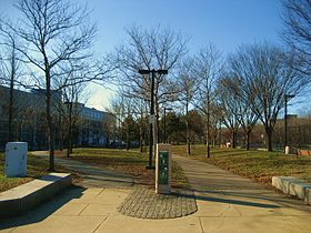
Southwest Corridor Park as seen from Ruggles Street looking south.
|
|
| Country | United States |
|---|---|
| State | Massachusetts |
| County | Suffolk |
| Municipality | Boston |
| Coordinates | 42°19′25″N 71°05′57″W / 42.32361°N 71.09917°WCoordinates: 42°19′25″N 71°05′57″W / 42.32361°N 71.09917°W |
| Area | 52 acres (21 ha) |
| Opened | 1987 |
| Management | Massachusetts Department of Conservation and Recreation |
| - location | 38 New Heath Street, Jamaica Plain, Massachusetts |
| - coordinates | 42°19′35″N 71°05′56″W / 42.32639°N 71.09889°W |
| Website: Southwest Corridor Park | |
Southwest Corridor Park is a linear urban park in Boston, Massachusetts, part of the Metropolitan Park System of Greater Boston and managed by the Massachusetts Department of Conservation and Recreation (DCR). It extends from the South End and Back Bay neighborhoods south for almost five miles (8 km), ending in the Forest Hills section of Jamaica Plain in what was originally planned to be the alignment for Interstate 95 to Boston. It closely follows the routes of regional Amtrak and Commuter Rail lines and the Massachusetts Bay Transportation Authority (MBTA) Orange Line rapid transit rail line, from its Back Bay Station to its terminus at Forest Hills station. It features tennis courts, basketball courts, playgrounds, and walking, jogging, and biking paths.
Starting in the 1960s, hundreds of acres of South End, Roxbury and Jamaica Plain housing were razed along what became known as the Southwest Corridor to build a 4.6 mile (7.4 km) section of Interstate 95 to be called the Southwest Expressway into downtown Boston. This mass demolition sparked massive community protest, which was marked by the painting of "STOP I-95 — PEOPLE BEFORE HIGHWAYS" on a local train-track wall, as a harbinger of the Southwest Corridor's future rail transit and community park use.
The protest prompted Governor Francis W. Sargent to cancel the highway project in 1969, and to become a strong advocate for changing the federal laws governing aid to states for highway construction so that more funds were available for mass transit projects such as subways and light-rail vehicles. I-95 was then routed along the existing Massachusetts Route 128 corridor in the suburbs. In 1973, Congress approved the Interstate Transfer Option, which allowed states to transfer federal funding for highways to mass transit projects.
...
Wikipedia


