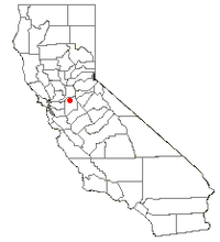
South Woodbridge, California
| South Woodbridge | |
|---|---|
| former census-designated place | |
 Location of South Woodbridge, California |
|
| Coordinates: 38°9′15″N 121°18′22″W / 38.15417°N 121.30611°WCoordinates: 38°9′15″N 121°18′22″W / 38.15417°N 121.30611°W | |
| Country |
|
| State |
|
| County | San Joaquin |
| Government | |
| • Senate | Tom Berryhill (R) |
| • Assembly | Alan Nakanishi (R) |
| • U. S. Congress | Jerry McNerney (D) |
| Area | |
| • Total | 1.0 km2 (0.4 sq mi) |
| • Land | 1.0 km2 (0.4 sq mi) |
| • Water | 0.0 km2 (0.0 sq mi) |
| Population (2000) | |
| • Total | 2,825 |
| • Density | 2,963.4/km2 (7,675.1/sq mi) |
| Time zone | PST (UTC-8) |
| • Summer (DST) | PDT (UTC-7) |
| ZIP code | 95258 |
| Area code(s) | 209 |
| FIPS code | 06-73461 |
South Woodbridge was a former census-designated place (CDP) in San Joaquin County, California, United States. The population was 2,825 at the 2000 census. For the 2010 census, the CDP's of South Woodbridge and North Woodbridge were merged into Woodbridge.
South Woodbridge is located at 38°9′15″N 121°18′22″W / 38.15417°N 121.30611°W (38.154118, -121.306008).
According to the United States Census Bureau, the CDP had a total area of 0.4 square miles (1.0 km²), of which, 0.4 square miles (1.0 km²) of it was land and 2.63% was water.
As of the census of 2000, there were 2,825 people, 891 households, and 733 families residing in the CDP. The population density was 7,675.2 people per square mile (2,947.9/km²). There were 914 housing units at an average density of 2,483.2 per square mile (953.8/km²). The racial makeup of the CDP was 76.21% White, 0.14% African American, 0.99% Native American, 4.85% Asian, 0.04% Pacific Islander, 13.73% from other races, and 4.04% from two or more races. Hispanic or Latino of any race were 27.40% of the population.
...
Wikipedia
