South Whitehall Township, Pennsylvania
| South Whitehall Township | |
| Township | |
| Country | United States |
|---|---|
| State | Pennsylvania |
| County | Lehigh |
| Elevation | 443 ft (135.0 m) |
| Coordinates | 40°36′56″N 75°33′01″W / 40.61556°N 75.55028°WCoordinates: 40°36′56″N 75°33′01″W / 40.61556°N 75.55028°W |
| Area | 17.2 sq mi (44.5 km2) |
| - land | 17.1 sq mi (44 km2) |
| - water | 0.1 sq mi (0 km2), 0.58% |
| Population | 19,180 (2010) |
| Density | 1,115.1/sq mi (430.5/km2) |
| Established | 1810 |
| Timezone | EST (UTC-5) |
| - summer (DST) | EDT (UTC-4) |
| ZIP Code | 18104 |
| Area code | 610 |
| Code 2 | 484 |
|
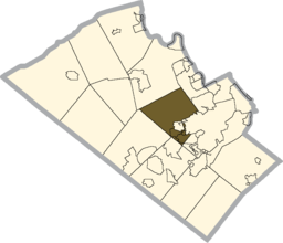
Location of South Whitehall Township in Lehigh County
|
|
|
Location of Pennsylvania in the United States
|
|
| Website: http://southwhitehall.com | |
South Whitehall Township is a township in Lehigh County, Pennsylvania, in the United States. It is a suburb of Allentown, Pennsylvania, in the Lehigh Valley area of the state. The population of South Whitehall Township was 19,180 at the 2010 census. It is home to the Lehigh Valley interchange of the Northeast Extension of the Pennsylvania Turnpike and Dorney Park, as well it has the distinction of having the second highest tax rate of any township in Lehigh County.
The first settlers of the Lehigh Valley region were Germans who emigrated from earlier settlements along the Perkiomen Creek. The earliest settlers arrived in the region over a 20-year period beginning in about 1732. The immigration of the Germans and other European natives, including Swiss and Huguenots, was aided by William Penn and his friends. The land lying south of the South Mountain was given to William Penn in 1713 by the Lenni Lenape Indians. The land of Lehigh County lying between the Blue Mountain and the Lehigh Mountains was given to Penn's sons by the Lenni Lenapes in 1732. Emigrants sought the fertile, limestone valley flanking rivers and streams such as the Jordan Creek.
One of the earliest tracts of land purchased in the Township was by Nicholas Kern who bought tracts of land on December 3, 1735 and October 28, 1737. Some of this was sold to Lorenz Guth on February 27, 1739. Guth continued to buy land in the area of the Reformed church property and also in the Guthsville area. By 1769 his holdings totaled 759 acres (3.07 km2). The Lorenz Guth house near Wehr's Dam still stands in excellent condition and is a fine example of colonial architecture.
...
Wikipedia


