South Side Flats (Pittsburgh)
| South Side Flats | |
|---|---|
| Neighborhood of Pittsburgh | |
 |
|
| Country | United States |
| State | Pennsylvania |
| County | Allegheny County |
| City | Pittsburgh |
| Area | |
| • Total | 0.94 sq mi (2.4 km2) |
| Population (2000) | |
| • Total | 5,726 |
| • Density | 6,100/sq mi (2,400/km2) |
|
East Carson Street Historic District
|
|

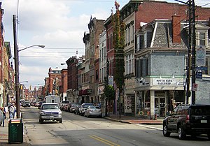
East Carson and 13th in 2008.
|
|
| Location | Roughly E. Carson St. from 9th to 24th St., Pittsburgh, Pennsylvania |
| Coordinates | 40°25′43.76″N 79°59′8.08″W / 40.4288222°N 79.9855778°WCoordinates: 40°25′43.76″N 79°59′8.08″W / 40.4288222°N 79.9855778°W |
| Built | 1850 |
| Architect | Multiple |
| Architectural style | Italianate, Romanesque, Second Empire |
| NRHP Reference # | 83004183 |
| Significant dates | |
| Added to NRHP | November 17, 1983 |
| Designated CPHS | August 16, 1993, and expanded June 1999 |
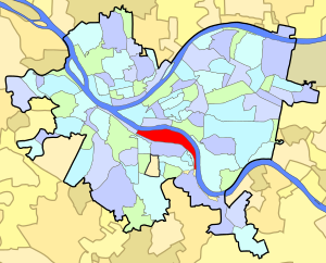
The South Side Flats is a neighborhood in Pittsburgh, Pennsylvania's South Side area. It is located just south of the Monongahela River. The neighborhood has one of the City of Pittsburgh’s largest concentrations of 19th-century homes, which has prompted outsiders to call the neighborhood the City’s Georgetown. It includes many bars and restaurants as well as residences. The main throughway in the South Side Flats is East Carson Street. This street is home to a significant portion of Pittsburgh's nightlife.
The South Side was once composed of a number of smaller communities. These included Birmingham and East Birmingham, both named for the English Midlands industrial center, Birmingham; Ormsby, originally a part of East Birmingham, incorporated as a borough in 1866; South Pittsburgh, the area immediately adjacent to the Smithfield Street Bridge, and Monongahela, named for the adjacent Monongahela River. These boroughs were collectively annexed to the city in 1872.
The South Side and much of the hillsides to its south had been granted to Major John Ormsby in 1763, in recognition his assistance in the building of Fort Pitt. By the 1770s, Ormsby had built an estate on these lands and established a ferry for connecting his home with the community in Pittsburgh.
In 1811, Ormsby’s son-in-law, Dr. Nathaniel Bedford, laid out a town on the flats, naming it Birmingham in tribute to his native city. Bedford had come to Pittsburgh around 1770 and was the first practicing physician in the district known as Allegheny County. He named the streets after his Ormsby’s children; names which the South Side streets still bear—Mary, Jane, Sarah, Sidney. Carson St. was named after a sea captain who lived in Philadelphia and was a friend of Dr. Bedford. In the early days it was part of the Washington Pike, the main road to Washington, Pennsylvania. The nearby municipality of Mount Oliver would be named for John Ormsby’s son Oliver Ormsby. The two areas were once connected by a coal incline run by the Keeling Coal Company, now the site of South Side Park. Birmingham quickly became a sizable industrial center because of the easy access to river and rail transport. The region would first become a center of glass production, followed by a concentration of iron and steel manufacturing. In 1850, Benjamin Franklin Jones invested in a South Side iron works. During the depression of 1873, he formed a partnership with a banker, James H. Laughlin. The firm of Jones and Laughlin Steel Company would eventually become the South Side’s largest employer. By 1910, it would employ over 15,000 workers. The expansion of the plant in 1950 would require the demolition of residential homes between 31st and 33rd streets.
...
Wikipedia


