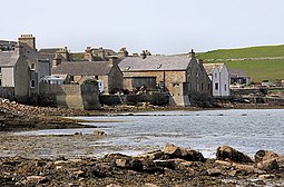
South Ronaldsay
| Norse name | Rognvaldsey |
|---|---|
| Meaning of name | Old Norse for "Rognvald/Ronald's island" |
 St Margaret's Hope on South Ronaldsay |
|
| Location | |
|
South Ronaldsay shown within Orkney
|
|
| OS grid reference | ND449899 |
| Coordinates | 58°47′N 2°57′W / 58.78°N 2.95°W |
| Physical geography | |
| Island group | Orkney |
| Area | 4,980 hectares (19.2 sq mi) |
| Area rank | 22 |
| Highest elevation | Ward Hill 118 metres (387 ft) |
| Administration | |
| Sovereign state | United Kingdom |
| Country | Scotland |
| Council area | Orkney Islands |
| Demographics | |
| Population | 909 |
| Population rank | 16 |
| Population density | 18.3 people/km2 |
| Largest settlement | St Margaret's Hope |
| References | |
South Ronaldsay is one of the Orkney Islands off the north coast of Scotland. It is linked to the Orkney Mainland by the Churchill Barriers, running via Burray, Glimps Holm and Lamb Holm.
With an area of 4,980 hectares (19.2 square miles), it is the fourth largest of the Orkney islands after The Mainland, Hoy and Sanday.Ferries sail from Burwick on the island to John o' Groats on the Scottish mainland and from St Margaret's Hope to Gills Bay.
South Ronaldsay's main village is St Margaret's Hope, Orkney's third largest settlement. It is named either after Margaret, Maid of Norway, the heir to the Scottish throne who died in Orkney age seven or possibly St. Margaret. The village has a small blacksmith's museum and is known for its annual Boys' Ploughing Match. During this event young girls and boys dressed in dark jackets play the part of the horses and young boys using miniature ploughs compete with one another at ploughing a 4-foot square rig in the nearby sands.
The cardinal points of the island are Ayre of Cara, by Churchill Barrier no. 4 (north), Grim Ness (east), Brough Ness, (south) and Hoxa Head, (west). The highest elevation is Ward Hill, which reaches 118 metres (387 ft). This name is common one in Orkney for the highest point on an island and comes from the historic use of these places used for the lighting of warning beacons.
...
Wikipedia

