South Park, Surrey
| Reigate | |
|---|---|
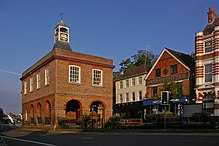
 Reigate Old Town Hall |
|
| Reigate shown within Surrey | |
| Population | 21,820 |
| OS grid reference | TQ2649 |
| • London | 19.1 mi (30.7 km) N by NE |
| District | |
| Shire county | |
| Region | |
| Country | England |
| Sovereign state | United Kingdom |
| Post town | REIGATE |
| Postcode district | RH2 |
| Dialling code | 01737 |
| Police | Surrey |
| Fire | Surrey |
| Ambulance | South East Coast |
| EU Parliament | South East England |
| UK Parliament | |
Reigate /ˈraɪɡeɪt/ is a town of over 20,000 inhabitants in eastern Surrey, England. It is in the London commuter belt and one of three towns in the borough of Reigate and Banstead. It is sited at the foot of the North Downs and extends over part of the Greensand Ridge. Reigate has a medieval castle and has been a market town since the medieval period, when it also became a parliamentary borough.
Colley Hill, one mile (1.6 km) north-west of Reigate, is 722 feet (220 m) high. Reigate Hill, 2.5 miles (4.0 km) due east of Colley Hill, is 771 feet (235 m) high, and they both have panoramas along the North Downs Way.
There are neolithic flint mines on the ridge of the North Downs above Reigate. Bronze Age settlement in the area is indicated by barrows on Reigate Heath. A Bronze Age spearhead was recovered on Park Hill in Reigate Priory Park. In 2004 a Roman tile kiln, dated from around AD 92 (pictured left), was recovered from the grounds of Rosehill in Doods Way. Tiles on the Rosehill site were first discovered in the 1880s. The tiles would have been used for important buildings in the area. The Rosehill find is the oldest recorded use of Reigate stone (ironstone of the Upper Greensand) for ashlar work.
...
Wikipedia

