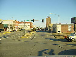
South McAlester, Oklahoma
| McAlester, Oklahoma | |
|---|---|
| City | |

Downtown McAlester
|
|
 Location of McAlester, Oklahoma |
|
| Location in the United States | |
| Coordinates: 34°55′59″N 95°45′59″W / 34.93306°N 95.76639°WCoordinates: 34°55′59″N 95°45′59″W / 34.93306°N 95.76639°W | |
| Country | United States |
| State | Oklahoma |
| County | Pittsburg |
| Area | |
| • Total | 15.8 sq mi (41.0 km2) |
| • Land | 15.7 sq mi (40.6 km2) |
| • Water | 0.1 sq mi (0.4 km2) |
| Elevation | 735 ft (224 m) |
| Population (2010) | |
| • Total | 18,363 |
| • Density | 1,133.1/sq mi (437.5/km2) |
| Time zone | Central (CST) (UTC-6) |
| • Summer (DST) | CDT (UTC-5) |
| ZIP codes | 74501-74502 |
| Area code(s) | 539/918 |
| FIPS code | 40-44800 |
| GNIS feature ID | 1095202 |
| Website | McAlester, Oklahoma official website |
McAlester is a city in and county seat of Pittsburg County, Oklahoma, United States. The population was 18,363 at the 2010 census, a 3.4 percent increase from 17,783 at the 2000 census, making it the largest city in the former Choctaw Nation of Oklahoma, followed by Durant. The town gets its name from J.J. McAlester, an early settler and businessman, who later became Lieutenant Governor of Oklahoma.
McAlester is the home of the Oklahoma State Penitentiary, site of an "inside the walls" prison rodeo from which ESPN's SportsCenter once broadcast. Oklahomans sometimes refer to the state prison simply as "Big Mac" or "McAlester".
McAlester is home to many of the employees of the McAlester Army Ammunition Plant. This facility makes essentially all of the bombs used by the United States military. In 1998 McAlester became the home of the Defense Ammunition Center (DAC) which moved from Savanna, Illinois, and relocated as a tenant on McAlester Army Ammunition Plant.
The crossing of the east-west California Road with the north-south Texas Road formed a natural point of settlement in Tobucksy County of the Choctaw Nation. Alyssia Young, who emigrated from Mississippi to the Indian Territory, first established a settlement at the intersection of the two roads in 1838. The town was named Perryville after James Perry, member of a Choctaw family, who established a trading post. At one time Perryville was the capital of the Choctaw Nation and County Seat of Tobucksy County. During the American Civil War, the Choctaw allied with the Confederate States of America (CSA) as the war reached Indian Territory.
...
Wikipedia

