South Holmwood
| South Holmwood | |
|---|---|
 South Holmwood from Redlands Wood within the parish, a foothill of Leith Hill. St Mary Magdalene is visible to the far right and Holmwood Common contains all of the wood on the far side. |
|
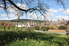
 View of central South Holmwood looking towards the Surrey Hills AONB. |
|
| South Holmwood shown within Surrey | |
| Area | 7.73 km2 (2.98 sq mi) |
| Population | 895 (Civil Parish) |
| • Density | 116/km2 (300/sq mi) |
| OS grid reference | TQ1745 |
| Civil parish |
|
| District | |
| Shire county | |
| Region | |
| Country | England |
| Sovereign state | United Kingdom |
| Post town | Dorking |
| Postcode district | RH5 |
| Dialling code | 01306 |
| Police | Surrey |
| Fire | Surrey |
| Ambulance | South East Coast |
| EU Parliament | South East England |
| UK Parliament | |
South Holmwood -/hoʊmwʊd/ is a semi-rural village in Surrey, England. It can be considered cognate with its wider civil parish, which stretches to the east to embrace Holmwood Common. However, it does not include Mid Holmwood, or North Holmwood, the latter being contiguous with Dorking. Betchett's Brook is the southern boundary and runs through a small locality known as Holmwood Corner. Reflecting Victorian naming of a railway station, Holmwood railway station is squarely within the parish of Capel but connected to the village by a curved path passing through Holmwood Corner Common.
Centred 3 miles (4.8 km) south of Dorking, South Holmwood is on the A24 London to Worthing road, a dual carriageway through the village.
Holmwood forms part of Mole Valley Borough Council's area; the main settlement is a small, clustered area bypassed by the A24 road. The smaller settlement of Holmwood Corner is half within the district, but the part beyond Betchett's Brook is considered to be in Beare Green, which is also convenient to the railway station, see Transport.
A country path, with a footbridge across the brook runs between the houses in Holmwood Corner, to the station at the end of Bregsell's Lane (running underneath the A24 and railway line). This forms a gentle curve through Holmwood Corner Common. A pavement on the opposite side of the dual carriageway feeds into a footpath that runs by the Anglican parish church to similarly connect South Holmwood's main cluster of residential streets.
Moor Cottage, South Holmwood, was the birthplace of the novelist E. Arnot Robertson (1903–1961).
...
Wikipedia

