South Holland IDB
| South Holland IDB | |
|---|---|
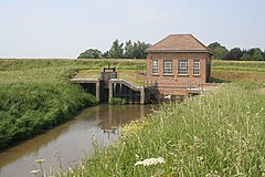
 Lord's Drain pumping station was built in 1962 and pumps into the River Welland. |
|
| South Holland IDB shown within Lincolnshire | |
| OS grid reference | TF358248 |
| Shire county | |
| Region | |
| Country | England |
| Sovereign state | United Kingdom |
| EU Parliament | East Midlands |
South Holland IDB is an English internal drainage board set up under the terms of the Land Drainage Act 1930. It has responsibility for the land drainage of 148.43 square miles (384.4 km2) of low-lying land in South Lincolnshire. It is unusual as its catchment area is the same as the area of the drainage district, and so it does not have to deal with water flowing into the area from surrounding higher ground. No major rivers flow through the area, although the district is bounded by the River Welland to the west and the River Nene to the east.
A ribbon either side of the route from Spalding to Sutton Bridge was populated in Roman times, and was again evident in the Domesday Book. Enclosing and reclamation of the salt marsh to the north of this area took place from the seventeenth century, and drainage was overseen by the Court of Sewers. In 1793, the South Holland Drainage District was set up by Act of Parliament, and carried out extensive drainage work, but the schemes were hampered by the state of the River Nene outfall. This was replaced in 1832, and allowed the district to lower their own sluice in 1852, to provide better gravity discharge. The need to grow more food during and after the Second World War resulted in large areas of grassland being ploughed up for agriculture, and the drains were made deeper and wider to improve the soil conditions. The main outfall sluice was again rebuilt in 1937, and its construction involved the first use of well point dewatering equipment in England.
In 1949, the first electric pumping station was installed, and several more were built in the following years. Heavy rainfall in July 1968 indicated that the district was still at risk from flooding, and several more electric pumping stations were commissioned. More than half of the district now relies on pumping for its flood protection, although most stations still have a gravity outfall, to cope with breakdowns or power failures.
The South Holland IDB is responsible for the land drainage of an area of 148.43 square miles (384.4 km2), which is broadly centred on the market town of Holbeach in the South Holland district of Lincolnshire. Its north-eastern boundary is formed by The Wash. Its eastern boundary follows the River Nene inland to Tydd Gote, where it turns to the west, passing near to the villages of Tydd St Mary and Sutton St James. It then turns to the south to include the village of Holbeach Drove and the hamlet of Shepeau Stow, before turning to the north again to Whaplode Drove. From there it turns to the west to reach the New River, which it follows northwards until its junction with the River Welland, which then forms the western boundary back to The Wash.
...
Wikipedia

