South Dalton
| South Dalton | |
|---|---|
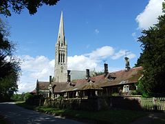
 St Mary's Church seen beyond the village alms houses |
|
| South Dalton shown within the East Riding of Yorkshire | |
| OS grid reference | SE966453 |
| • London | 165 mi (266 km) S |
| Civil parish | |
| Unitary authority | |
| Ceremonial county | |
| Region | |
| Country | England |
| Sovereign state | United Kingdom |
| Post town | BEVERLEY |
| Postcode district | HU17 |
| Dialling code | 01430 |
| Police | Humberside |
| Fire | Humberside |
| Ambulance | Yorkshire |
| EU Parliament | Yorkshire and the Humber |
| UK Parliament | |
South Dalton is a village in the East Riding of Yorkshire, England. It is situated 1 mile (1.6 km) to the west of the B1248 road, and approximately 6 miles (10 km) north-east from the market town of Market Weighton and 5 miles (8 km) north-west from the market town of Beverley. Etton lies 1.5 miles (2.4 km) to the south-east. North Dalton is approximately 4.5 miles (7 km) north-west, with the villages of Middleton on the Wolds and Lund between.
South Dalton forms part of the civil parish of Dalton Holme.
The village forms part the Dalton Estate, owned and managed by the Hotham family which has possessed land in the area for generations. The 18th-century hall is the home of Lord Hotham. The Dalton Estate office is within the village. The Estate houses are of rows of cottages and Tudor style houses, some with date plates dating as far back as 1706.
According to A Dictionary of British Place Names the village name derives from the Old English for a "farmstead or village in a valley." South Dalton is listed in the Domesday Book as "Delton". At the time of the survey the settlement was in the Hundred of Sneculfcros in the East Riding of Yorkshire. It contained twelve households, twelve villagers, and six ploughlands. In 1066 Ealdred, the Archbishop of York, held the Lordship, this transferring by 1086 to the canons of Beverley, with Thomas of Bayeux, the later Archbishop of York, as Tenant-in-chief to King William I. By 1260 the settlement name was recorded as "Suthdalton".
...
Wikipedia

