South Andros
| District of South Andros | |
|---|---|
 |
|
| Coordinates: 25°4′N 77°20′W / 25.067°N 77.333°W | |
| Country | Bahamas |
| Island |
|
| Established | 1996 |
| Government | |
| • Type | District Council |
| • Chief Councillor | Fairdale Smith |
| • Deputy Chief Councillor | Jeffery Johnson |
| Population (2010) | |
| • Total | 3,592 |
| Time zone | EST (UTC−5) |
| • Summer (DST) | EDT (UTC−4) |
| Area code(s) | 242 |
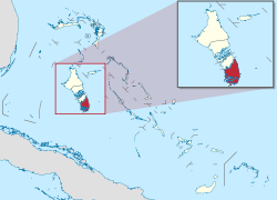
South Andros is a district of the nation of the Bahamas.
Geographically, South Andros is the southernmost third of the land mass colloquially called Andros, which includes the districts of North Andros, Central Andros, Mangrove Cay and South Andros. In 2010, the district had 3,592 inhabitants.
The districts are divided by broad unspanned "creeks", some of which offer public ferry crossing; otherwise the only way to travel from one district to another is by private plane or boat. South Andros is accessed from Nassau via commercial airline (currently two trips daily from Nassau to South Andros Airport), from the U.S. via two flights commercially from Fort Lauderdale International and other islands by charter airplane (usually from Fort Lauderdale, Florida), and from anywhere by private boat. A public ferry runs daily between South Andros and its northern neighboring Mangrove Cay which is also considered a part of South Andros. The mail boat comes to Andros once a week from Nassau, leaving Nassau Monday night and arriving at Drigg's Hill port on South Andros on Tuesday morning, which brings the majority of all imports and supplies to the island, from milk to petrol.
The Queen's Highway, a two lane paved and illuminated road without traffic lights, runs approximately 40 miles (64 km) from the northernmost edge of South Andros which is the port of Drigg's Hill, to the dockside settlement of Mars Bay. At Mars Bay the road ends in a cul de sac but the island extends approximately 20 further miles south without roads or services, inaccessible except by boat. In its course from Drigg's Hill to Mars Bay, the highway crosses two bridges, one at Deep Creek and one further south at Little Creek, both refurbished in 2012.
Almost the entire population of South Andros lives in housing abutting the Queen's Highway and a few short, paved roads trailing off it. The only other significant road is that leading west, inland, along the north side of Deep Creek, to Black Point, where there are a handful of additional homes. South Andros' widest point is about 20 miles (32 km) east to west, but only the eastern fringe is inhabited, as most of the island consists of salty marsh and tidal estuaries.
...
Wikipedia
