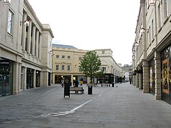
SouthGate, Bath

SouthGate Place, the central plaza
|
|
| Location | Bath, Somerset, England |
|---|---|
| Coordinates | 51°22′43″N 2°21′30″W / 51.3786°N 2.3583°WCoordinates: 51°22′43″N 2°21′30″W / 51.3786°N 2.3583°W |
| Opening date | 4th November 2009 |
| Developer | Multi Development UK |
| Management | Simon Pullen |
| Owner | Aviva Investors and British Land |
| Architect | Chapman Taylor, Wilkinson Eyre Architects, T+T Design |
| No. of stores and services | 56 |
| No. of anchor tenants | 1 (Debenhams) |
| Parking | 876 |
| Website | www.southgatebath.com |
SouthGate is a shopping centre in Bath, Somerset, England, It is home to over 50 shops, 6 restaurants, 99 homes and an 860-space underground car park. It replaced a shopping centre which was demolished in 2007.
The new centre developed by Multi Corporation UK is more than double the size of the previous space and provides 37,000 sq metres of retail space, 3,500 sq metres of leisure space, 2,300 sq metres of restaurant space plus 99 residential units. It was designed by Chapman Taylor to mimic Georgian architecture with a Bath stone facade; the infrastructure of the buildings is modern concrete. The first owners were the Lend Lease Group. In 2013 British Land purchased a 50% stake for £101 million, leaving Aviva Investors as owners of the other 50%.
The development won the Georgian Group Architectural Giles Worsley Award for a New Building in Georgian Context in 2010.
On the site prior to this development was the Southgate Shopping Centre designed by Owen Luder, architect of the Tricorn Centre in Portsmouth and Trinity Square Carpark in Gateshead; and, on the east half of the site, the former Bath bus station. The Bath bus station was demolished and a new bus station was opened to the south of the site and just to the west of the main Bath Spa railway station.
The new SouthGate precinct occupies roughly the west half of an area of land once known as The Ham that existed up until around the time of Jane Austen. The Ham was outside the line of the original city wall, which at one time formed The Ham's north border. (The first section of that wall, starting at the city's south gate, ran east roughly along the present-day New Orchard Street.) The Ham is remembered in the name Ham Gardens, a small street towards the north side of the precinct off Philip Street.
...
Wikipedia
