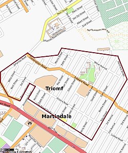
Sophiatown, Gauteng
|
Sophiatown Sof'town, Kofifi, Triomf |
|
|---|---|
 |
|
|
|
|
| Coordinates: 26°10′36″S 27°58′54″E / 26.1767°S 27.9816°ECoordinates: 26°10′36″S 27°58′54″E / 26.1767°S 27.9816°E | |
| Country | South Africa |
| Province | Gauteng |
| Municipality | City of Johannesburg |
| Main Place | Johannesburg |
| Established | 1899 |
| Area | |
| • Total | 0.95 km2 (0.37 sq mi) |
| Population (2011) | |
| • Total | 5,371 |
| • Density | 5,700/km2 (15,000/sq mi) |
| Racial makeup (2011) | |
| • Black African | 26.8% |
| • Coloured | 25.8% |
| • Indian/Asian | 5.1% |
| • White | 41.4% |
| • Other | 0.8% |
| First languages (2011) | |
| • Afrikaans | 44.5% |
| • English | 31.9% |
| • Tswana | 4.7% |
| • Zulu | 4.5% |
| • Other | 14.4% |
| Postal code (street) | 2092 |
|
|
Sophiatown /soʊˈfaɪətaʊn/, also known as Sof'town or Kofifi, is a suburb of Johannesburg, South Africa. Sophiatown was a legendary black cultural hub that was destroyed under apartheid, rebuilt under the name of Triomf, and in 2006 officially returned to its original name. Sophiatown was one of the oldest black areas in Johannesburg and its destruction represents some of the excesses of South Africa under apartheid. Despite the violence and poverty, it was the epicentre of politics, jazz and blues during the 1940s and 1950s. It produced some of South Africa's most famous writers, musicians, politicians and artists.
Sophiatown was originally part of the Waterfall farm. Over time it included the neighbouring areas of Martindale and Newclare. It was purchased by a speculator, Hermann Tobiansky, in 1897. He acquired 237 acres four miles or so west of the centre of Johannesburg. The private leasehold township was surveyed in 1903 and divided into almost 1700 small stands. The township was named after Tobiansky's wife, Sophia, and some of the streets were named after his children Toby, Gerty, Bertha and Victoria. Before the enactment of the Natives Land Act, 1913, black South Africans had freehold rights, and they bought properties in the suburb. The distance from the city centre was seen as disadvantageous and after the City of Johannesburg built a sewage plant nearby, the area seemed even less attractive. Because of these and other reasons most of the whites had moved out by 1920, leaving behind a vibrant multi-racial community. By the late 1940s Sophiatown had a population of nearly 54 000 Black Africans, 3 000 Coloureds, 1 500 Indians and 686 Chinese.
As neighbouring white working-class areas, such as Westdene and Newlands, developed adjacent to Sophiatown, the perception arose that the suburb was too close to white suburbia. From 1944 onwards, the Johannesburg City Council planned to move the black population out of the Western Areas, including Sophiatown. After the election victory of the National Party in 1948, relocation plans were debated at the level of national politics. Under the Immorality Amendment Act, No 21 of 1950, people of mixed races could not reside together, which made it possible for the government to segregate the different races.
...
Wikipedia


