Soperton, Georgia
| Soperton, Georgia | |
|---|---|
| City | |
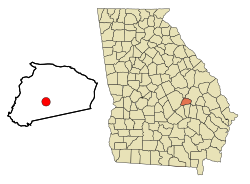
 Location in Treutlen County and the state of Georgia |
|
| Coordinates: 32°22′34″N 82°35′34″W / 32.37611°N 82.59278°WCoordinates: 32°22′34″N 82°35′34″W / 32.37611°N 82.59278°W | |
| Country | United States |
| State | Georgia |
| County | Treutlen |
| Government | |
| • Mayor | Royce Fowler |
| • City Council | Wade Clark / John Koon / Izell Stephens / JB Johnson / Xandra Brown |
| Area | |
| • Total | 3.2 sq mi (8.5 km2) |
| • Land | 3.2 sq mi (8.4 km2) |
| • Water | 0 sq mi (0.1 km2) |
| Elevation | 295 ft (90 m) |
| Population (2010) | |
| • Total | 3,115 |
| • Density | 973.4/sq mi (366.4/km2) |
| Time zone | Eastern (EST) (UTC-5) |
| • Summer (DST) | EDT (UTC-4) |
| ZIP code | 30457 |
| Area code(s) | 912 |
| FIPS code | 13-71772 |
| GNIS feature ID | 0323223 |
| Website | City of Soperton |
Soperton is a city in Treutlen County, Georgia, United States. The population was 3,115 at the 2010 census, up from 2,824 at the 2000 census. The city is the county seat of Treutlen County.
The city was named after Benjamin Franklin Soper, a railroad engineer.
Soperton is located at 32°22′34″N 82°35′34″W / 32.37611°N 82.59278°W (32.376067, -82.592724).
According to the United States Census Bureau, the city has a total area of 3.3 square miles (8.5 km2), of which, 3.2 square miles (8.3 km2) of it is land and 0.04 square miles (0.10 km2) of it (0.61%) is water.
As of the census of 2000, there were 2,824 people, 1,096 households, and 737 families residing in the city. The population density was 870.6 people per square mile (336.5/km²). There were 1,215 housing units at an average density of 374.6 per square mile (144.8/km²). The racial makeup of the city was 46.67% White, 51.84% African American, 0.04% Native American, 0.35% Asian, 0.39% from other races, and 0.71% from two or more races. Hispanic or Latino of any race were 0.92% of the population.
...
Wikipedia
