Slovene Istria
|
Slovene Istria Slovenska Istra (Slovene) Istria slovena (Italian) |
|
|---|---|
| Region | |
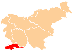
 Map of Slovenia highlighting the region location |
|
| Population (2002) | |
| • Total | 93,089 |
| Time zone | CET (UTC+01) |
| • Summer (DST) | CEST (UTC+02) |
Slovene Istria (Slovene: Slovenska Istra, Italian: Istria slovena) is a region in southwest of Slovenia. It comprises the northern part of the Istrian peninsula, and it is part of the wider geographical-historical region known as the Slovene Littoral (Primorska). Its largest urban center is Koper. Other large settlements are Izola, Piran and Portorož. The whole region has around 120 settlements. In its coastal area, both the Slovene and Italian languages are official.
The Slovene Riviera (Slovenska obala in Slovene) is located in Slovene Istria; both terms are sometimes used interchangeably, especially in the media, although the Slovenian Istria includes a wider geographical area.
The Istrian peninsula was known to Romans as the terra magica. Its name is derived from the Histri, an Illyrian tribe who, as accounted by the geographer Strabo, lived in the region. Romans described them as pirates who were hard to conquer due to the difficulty of navigating their territory. After two military campaigns, Roman legions finally subdued them in 177 BC. A lot of remains of ancient harbours and settlements still remain today, mostly in Ankaran, Hrvatini, Izola, Koper and Piran.
With the fall of the Western Roman Empire in 476, Istria was conquered by the Goths, the Byzantines. With the end of the 6th century, Carantanians arrived and built their first permanent settlement around the year 700. During Byzantine rule, it was shortly ruled by Avars. Istria was annexed by the Lombards in 751 and by the Avars in 774. It came under Frankish rule during the reign of Charlemagne, when his son Carloman conquered the peninsula in 789, and was incorporated into the Carolingian March of Friuli.
...
Wikipedia
