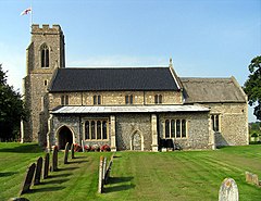
Sloley, Norfolk
| Sloley | |
|---|---|
 Saint Bartholomew parish church, Sloley, Norfolk |
|
| Sloley shown within Norfolk | |
| Area | 3.04 km2 (1.17 sq mi) |
| Population | 257 (parish, 2011 census) |
| • Density | 85/km2 (220/sq mi) |
| OS grid reference | TG292247 |
| • London | 128 miles (206 km) |
| Civil parish |
|
| District | |
| Shire county | |
| Region | |
| Country | England |
| Sovereign state | United Kingdom |
| Post town | NORWICH |
| Postcode district | NR12 |
| Dialling code | 01692 |
| Police | Norfolk |
| Fire | Norfolk |
| Ambulance | East of England |
| EU Parliament | East of England |
Sloley is a village and a civil parish in the English county of Norfolk. The village is 11.9 miles (19.2 km) north-northeast of Norwich, 13.6 miles (21.9 km) south-southeast of Cromer and 128 miles (206 km) north-east of London. The village lies 4.7 miles (7.6 km) south of the town of North Walsham.The nearest railway station is at Worstead for the Bittern Line which runs between Cromer and Norwich. The station is about 1 km (0.62 mi) from the centre of the village. The nearest airport is Norwich International Airport. The Village and parish of Sloley had in the 2001 census, a population of 255, increasing to 257 at the 2011 Census. The civil parish of Sloley has an area of 3.04 km2 (1.17 sq mi). For the purposes of local government, the village falls within the district of North Norfolk.
The parish of Sloley is situated in the northwest of the county of Norfolk. The parish is bounded on the south east with the parish of Tunstead, whilst to the west lies the parish of Scottow. The northern boundary is with the parishes of Westwick and Worstead. The north east corner is crossed north to south by the Bittern railway line which runs between Cromer and Norwich. Dissecting the parish east to west is New Barn lane which follows the route of an old Roman road which was an extension to the Fen Causeway and was thought to be a major East-West route which ran on to Smallburgh and possibly continued to Caister or an important port since eroded by the sea. The name Sloley comes from the 7th-century Old English for "sla" meaning "sloe", plus "leah", a wood or clearing; hence, "leah where sloes grew".
...
Wikipedia

