Sky Valley, Georgia
| Sky Valley, Georgia | |
|---|---|
| City | |

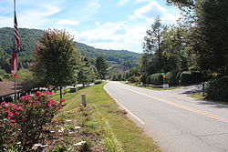
Street in Sky Valley
|
|
 Location in Rabun County and the state of Georgia |
|
| Coordinates: 34°59′10″N 83°19′29″W / 34.98611°N 83.32472°WCoordinates: 34°59′10″N 83°19′29″W / 34.98611°N 83.32472°W | |
| Country | United States |
| State | Georgia |
| County | Rabun |
| Area | |
| • Total | 3 sq mi (7.9 km2) |
| • Land | 3 sq mi (7.9 km2) |
| • Water | 0 sq mi (0 km2) |
| Elevation | 3,297 ft (1,005 m) |
| Population (2010) | |
| • Total | 272 |
| • Density | 73.7/sq mi (28/km2) |
| Time zone | Eastern (EST) (UTC-5) |
| • Summer (DST) | EDT (UTC-4) |
| ZIP code | 30537 |
| Area code(s) | 706 |
| FIPS code | 13-71282 |
| GNIS feature ID | 0330571 |
Sky Valley is a town in Rabun County, Georgia, United States and is nestled in a mountain valley on the northwest slopes of Rabun Bald, Georgia's second-highest peak. As of the 2000 census, the city had a total population of 250.
Since 1971, it is home to Sky Valley Resort, which features golfing, tennis and swimming. The resort formerly had the only winter ski area in Georgia, but after changing ownership in 2004, the resort's ski slopes were permanently closed. The only highway or other through-road is the Dillard/Highlands Road (Georgia 246 and N.C. 106) between Dillard, Georgia and Highlands, North Carolina. The northern city limit is the North Carolina state line, where the highway zigzags, crossing in five different places (two of which are into and out of the city).
Sky Valley is located at 34°59′10″N 83°19′29″W / 34.98611°N 83.32472°W (34.986008, -83.324688). Based on latitude, Sky Valley is the northernmost city in the state.
According to the United States Census Bureau, the city has a total area of 3.0 square miles (7.8 km2), all land. The elevation of the valley floor is approximately 3100 feet above sea level, while areas within the city limits on the slopes of Rabun Bald exceed 4200 feet. Sky Valley is Georgia's highest incorporated city and one of the highest municipalities in the eastern United States.
...
Wikipedia
