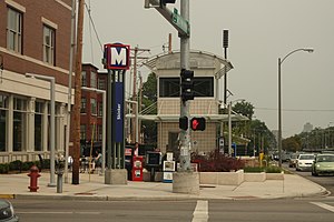
Skinker (St. Louis MetroLink)
| MetroLink light rail station | |||||||||||
 |
|||||||||||
| Location | 260 North Skinker Boulevard St. Louis, Missouri 63112 |
||||||||||
| Coordinates | 38°38′58″N 90°18′03″W / 38.649414°N 90.30082°WCoordinates: 38°38′58″N 90°18′03″W / 38.649414°N 90.30082°W | ||||||||||
| Owned by | Bi-State Development Agency | ||||||||||
| Operated by | Metro Transit | ||||||||||
| Line(s) | |||||||||||
| Tracks | 2 | ||||||||||
| Connections |
|
||||||||||
| Construction | |||||||||||
| Structure type | Underground | ||||||||||
| Disabled access | Yes | ||||||||||
| History | |||||||||||
| Opened | August 26, 2006 | ||||||||||
| Traffic | |||||||||||
| Passengers (2007) | 736 daily |
||||||||||
| Services | |||||||||||
|
|||||||||||
The Skinker St. Louis MetroLink subway station opened August 26, 2006 at the intersection of Skinker Boulevard and Forest Park Parkway near the boundary of St. Louis and University City, and serves the eastern portion of the Washington University main campus, the western portion of Forest Park, and area residents in the Skinker-DeBaliviere Neighborhood. It is a below-grade station, located under Skinker Boulevard at Forest Park Parkway, right by Kayak's.
...
Wikipedia
