Skerryvore
| Gaelic name | An Sgeir Mhòr |
|---|---|
| Meaning of name | The Great Skerry |
| Location | |
|
Skerryvore shown within Scotland
|
|
| OS grid reference | NL841265 |
| Coordinates | 56°19′30″N 7°06′40″W / 56.325°N 7.111°W |
| Physical geography | |
| Island group | Isle of Mull |
| Area | 26 m2 |
| Highest elevation | 3 m |
| Administration | |
| Sovereign state | United Kingdom |
| Country | Scotland |
| Council area | Argyll and Bute |
| Demographics | |
| Population | 0 |
| References | |

Skerryvore Lighthouse
|
|
|
Scotland
|
|
| Location | 12 miles south west of Tiree Argyll Scotland United Kingdom |
|---|---|
| Coordinates | 56°19′22.8″N 7°6′51.9″W / 56.323000°N 7.114417°W |
| Year first constructed | 1844 |
| Automated | 1994 |
| Deactivated | 1954-1959 |
| Construction | granite tower |
| Tower shape | tapered cylindrical tower with balcony and lantern incorporating heeper's quarters |
| Markings / pattern | unpainted tower, black lantern |
| Height | 48 metres (157 ft) |
| Focal height | 46 metres (151 ft) |
| Light source | solar power |
| Range | 23 nautical miles (43 km; 26 mi) |
| Characteristic | Fl W 10s. |
| Fog signal | one blast every 60s. |
| Admiralty number | A4096 |
| NGA number | 3996 |
| ARLHS number | SCO-215 |
| Managing agent | Northern Lighthouse Board |
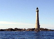
Skerryvore (from the Gaelic An Sgeir Mhòr meaning "The Great Skerry") is a remote reef that lies off the west coast of Scotland, 12 miles (19 kilometres) south-west of the island of Tiree. Skerryvore is best known as the name given to the lighthouse on the skerry, built with some difficulty between 1838 and 1844 by Alan Stevenson.
At a height of 156 feet (48 m) it is the tallest lighthouse in Scotland. The shore station was at Hynish on Tiree (which now houses the Skerryvore Lighthouse Museum); operations were later transferred to Erraid, west of Mull. The remoteness of the location led to the keepers receiving additional payments in kind. The light shone without a break from 1844 until a fire in 1954 shut down operations for five years. The lighthouse was automated in 1994.
In pre-historic times the rocks that now form Skerryvore were covered by the ice sheets that spread from Scotland out into the Atlantic Ocean beyond the Outer Hebrides. After the last retreat of the ice around 20,000 years ago, sea levels were up to 400 feet (120 m) lower than at present. Although the isostatic rise of land makes estimating post-glacial coastlines a complex task, circa 14,000 BP it is likely that the reef was at the south western end of a large island consisting of the modern islands of Tiree and Coll and the surrounding land.
Steadily rising sea levels would then have slowly isolated and finally all but submerged the shoals of Skerryvore, a barrier of innumerable metamorphic remnants that stretch for 8 miles (13 kilometres) lying in a south-westerly direction. A detailed survey undertaken in 1834 listed more than 130 main rocks including Am Bonn Sligheach (Boinshley) (Scottish Gaelic: The Deceitful Bottom) and Am Bogha Ruadh (Scottish Gaelic: The Red Submerged Rock).
...
Wikipedia


