Skegness
| Skegness | |
|---|---|
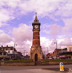
 Skegness Clock Tower |
|
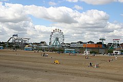
 Skegness from the pier |
|
| Skegness shown within Lincolnshire | |
| Population | 19,579 (2011 Census) |
| OS grid reference | TF5663 |
| • London | 115 mi (185 km) S |
| District | |
| Shire county | |
| Region | |
| Country | England |
| Sovereign state | United Kingdom |
| Post town | SKEGNESS |
| Postcode district | PE24, PE25 |
| Dialling code | 01754 |
| Police | Lincolnshire |
| Fire | Lincolnshire |
| Ambulance | East Midlands |
| EU Parliament | East Midlands |
| UK Parliament | |
Skegness (pronounced /ˌskɛɡˈnɛs/) is a seaside town and civil parish in the East Lindsey district of Lincolnshire, England, on the Lincolnshire coast of the North Sea, 43 miles (69 km) east of Lincoln. In the 2011 census Skegness civil parish had a population of 19,579.
The first Butlin's holiday resort opened in Skegness in 1936.
Longshore drift carries particles of sediment southwards along the Lincolnshire coast; at Skegness, the sand settles out in banks which run at a slight angle to the coast. The slightly elevated dune land sheltered the small natural harbour which the Danes found behind the banks. The finer sediment drifts on to reach the mud of the Wash, beyond Gibraltar Point.
The civil parish extends westwards along the A158 to the west side of the South View Hotel, and the boundary follows North Drain, bordering Burgh le Marsh. Just north of Mill Hill it borders Addlethorpe, passing to the west of Ash Tree Farm, the airfield and Skegness Water Leisure Park. At the north end of the leisure park it borders Ingoldmells, and the boundary follows to the south of Wall's Lane. The boundary crosses the A52 at a subway across the road, just south of the Butlin's camp. To the south of the hotel on the A158, the parish follows Main Drain, to the west of Warth Lane. Just south of Ivy House, it crosses the A52 and borders Croft. The boundary follows Cow Bank Drain, over a level crossing, to the north of Croft Grange, then passes through Bramble Hills, just north of Seacroft Golf Course to the sea.
...
Wikipedia

