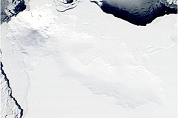
Siple Island
 |
|
|
Location of Siple Island
|
|
| Geography | |
|---|---|
| Location | Antarctica |
| Coordinates | 73°51′S 125°50′W / 73.850°S 125.833°WCoordinates: 73°51′S 125°50′W / 73.850°S 125.833°W |
| Area | 6,390 km2 (2,470 sq mi) |
| Area rank | 100th |
| Length | 110 km (68 mi) |
| Highest elevation | 3,110 m (10,200 ft) |
| Highest point | Mount Siple |
| Administration | |
|
None
|
|
| Demographics | |
| Population | Uninhabited |
| Additional information | |
| Administered under the Antarctic Treaty System | |
Siple Island is a 110 km (68 mi) long snow-covered island lying east of Wrigley Gulf along the Getz Ice Shelf off Bakutis Coast of Marie Byrd Land, Antarctica. Its centre is located at 73°51′S 125°50′W / 73.850°S 125.833°W.
Its area is 6,390 km2 (2,467 sq mi) and it is dominated by the dormant shield volcano Mount Siple, rising to 3,110 m (10,203 ft) – making this the 15th ranking island in the world by maximum elevation.
Island and mountain were named by the United States Advisory Committee on Antarctic Names (US-ACAN) in 1967 in honour of the Antarctic explorer Paul A. Siple (1909–1968), member of Admiral Byrd's expeditions.
...
Wikipedia

