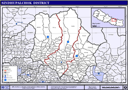
Sindhupalchowk District
|
|
|---|---|
| District | |
 |
|
| Coordinates: 27°46′N 85°42′E / 27.767°N 85.700°ECoordinates: 27°46′N 85°42′E / 27.767°N 85.700°E | |
| Country | Nepal |
| Region | Central (Madhyamanchal) |
| Zone | Bagmati |
| Headquarters | Chautara |
| Area | |
| • Total | 2,542 km2 (981 sq mi) |
| Highest elevation | 7,080 m (23,230 ft) |
| Lowest elevation | 850 m (2,790 ft) |
| Population (2011) | |
| • Total | 287,798 |
| • Density | 110/km2 (290/sq mi) |
| Time zone | NPT (UTC+5:45) |
Sindhupalchowk District (![]() सिन्धुपाल्चोक जिल्ला ) is a part of Province No. 3 and one of the seventy-five districts of Nepal, with an area of 2,542 km2 (981 sq mi). The district's headquarters is in Chautara. In 2006, 336,478 people resided in 79 village development committees, in 2011 there were 287,798.
सिन्धुपाल्चोक जिल्ला ) is a part of Province No. 3 and one of the seventy-five districts of Nepal, with an area of 2,542 km2 (981 sq mi). The district's headquarters is in Chautara. In 2006, 336,478 people resided in 79 village development committees, in 2011 there were 287,798.
The climatic zones found in the district comprise:
The major towns are Chautara, Bahrabise, Melamchi, Jalbire and Tatopani.
Although this district is close to Nepal's capital Kathmandu, it is one of the least developed districts in Nepal. The Arniko Highway, also called Kathmandu-Kodari Highway, (114 km) extending from Kathmandu to Kodari links this district with Tibet. The district is mountainous and rich in natural resources.
The district is easily accessible from Kathmandu. People depend entirely on agriculture for their survival. Since the district is hilly, the land is not very fertile, and the yield is very low. Almost every VDC has access to electricity, and roads connecting to the highway. Many NGOs and INGOs are working in the district in order to improve the living standards.
The Bhote Koshi, Indrawati, Sun Kosi and Bramhayani rivers flow through this district. Sunkoshi Hydropower station and Upper Bhotekoshi Hydropower station are hydropower stations connected to the national grid.Many Mini and large hydroelectricity plants are being constructed in different places.
...
Wikipedia
