Silver Gate, Montana
| Cooke City-Silver Gate, Montana | |
|---|---|
| CDP | |

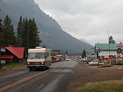
Entering Cooke City from the East
|
|
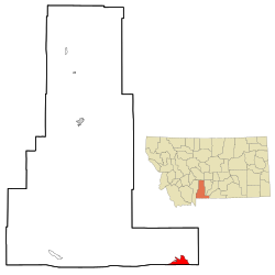
 Location of Cooke City-Silver Gate, Montana |
|
| Coordinates: 45°1′3″N 109°56′19″W / 45.01750°N 109.93861°WCoordinates: 45°1′3″N 109°56′19″W / 45.01750°N 109.93861°W | |
| Country | United States |
| State | Montana |
| County | Park |
| Area | |
| • Total | 10.0 sq mi (25.9 km2) |
| • Land | 10.0 sq mi (25.9 km2) |
| • Water | 0.0 sq mi (0.0 km2) |
| Elevation | 7,608 ft (2,318.9 m) |
| Population (2000) | |
| • Total | 140 |
| • Density | 14.0/sq mi (5.4/km2) |
| Time zone | Mountain (MST) (UTC-7) |
| • Summer (DST) | MDT (UTC-6) |
| Area code(s) | 406 |
| FIPS code | 30-17359 |
Cooke City-Silver Gate is a census-designated place (CDP) in Park County, Montana, United States. The population was 140 at the 2000 census. It sits toward the northeast of Yellowstone National Park on a road remaining open during the winter connecting through Tower Junction to Mammoth and north to Livingston, Montana. During the summer the road opens eastward to connect to Red Lodge, Montana via the Beartooth Highway on a scenic route rising about 10,000 feet elevation through the Absaroka Mountains. Its chief industry is tourism, which during the winter includes snowmobiling.
Cooke City-Silver Gate is located at 45°1′3″N 109°56′19″W / 45.01750°N 109.93861°W (45.017378, −109.938599), at an elevation of 7,608 feet (2,318 m).
According to the United States Census Bureau, the CDP has a total area of 10.0 square miles (26 km2), all of it land.
As of the census of 2000, there were 140 people, 79 households, and 27 families residing in the CDP. The population density was 14.0 people per square mile (5.4/km²). There were 247 housing units at an average density of 24.7 per square mile (9.5/km²). The racial makeup of the CDP was 97.86% White, 0.71% African American, 0.71% Native American, and 0.71% from two or more races.
...
Wikipedia
