Shotley Gate
| Shotley, Suffolk | |
|---|---|
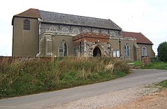
 St Mary's Church, Shotley |
|
| Shotley, Suffolk shown within Suffolk | |
| Population | 2,342 (2011) |
| OS grid reference | TM2463 |
| District | |
| Shire county | |
| Region | |
| Country | England |
| Sovereign state | United Kingdom |
| Post town | Ipswich |
| Postcode district | IP9 |
| Dialling code | 01473 |
| EU Parliament | East of England |
Shotley is the parish giving its name to the Shotley peninsula south of Ipswich, between the River Stour and the River Orwell in Suffolk, England. Shotley parish comprises the village of Shotley and the larger adjacent settlement of Shotley Gate. In 2001 there were 2,373 people living in Shotley.
The village of Shotley is about a mile northwest from the tip of the peninsula, and lies either side of the B1456 road (the Street). There are two entries for Shotley (Scoteleia) and an adjacent settlement of Kirkton (Cherchetuna) listed in the Domesday Book of 1086.
A school is located outside the village (half of 1 km east) opposite the turning into Oldhall Road. Oldhall Road is located east of the village leading north to St Mary's Church. The church contains a naval cemetery cared for by the Commonwealth War Graves Commission.
Shotley Hall is located near to the church. Rose Farm lies to the south of the village.
Shotley Parish Council holds its main meeting at the village hall at 19.00 hours every third Thursday of every month, while the Open Spaces and Amenities Committee meets most months on the second Thursday. Both are open to the public.
Shotley Gate is a settlement to the south of the village of Shotley at the tip of the peninsula.
By about 800 AD, the Vikings or Danes started to make an appearance in this area. Under the Peace of Wedmore in 878, all land north of the old Roman Watling Street, which ran from London to Chester, was given to the Viking leader, Guthrum. Shotley therefore became part of Danelaw. The peace was short-lived however, and following an unsuccessful Viking attack on Kent, Alfred King of Wessex attacked the enemy in East Anglia. The Anglo-Saxon Chronicle for the year 885 reads as follows: 'The same year sent King Alfred a fleet from Kent into East Anglia. As soon as they came to Stourmouth, there met them sixteen ships of the pirates, and they fought with them, took all the ships and slew the men. As they returned homeward with their booty, they met a large fleet of pirates and fought with them the same day, but the Danes had the victory'. It is possible that Bloody Point at Shotley took its name from this incident, however at that time the river entered the sea north of Felixstowe and so the area would not have been seen as the mouth of the Stour. It could also have derived this name late in the next century when the Vikings returned to the estuary in force, twice plundering Ipswich. Shotley Gate and the parish have a strategic position for protecting the ports of Felixstowe, Harwich and Ipswich and in 1865 the Shotley Battery fortifications were established.
...
Wikipedia

