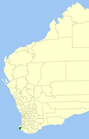
Shire of Augusta-Margaret River
|
Shire of Augusta-Margaret River Western Australia |
|||||||||||||
|---|---|---|---|---|---|---|---|---|---|---|---|---|---|

Location in Western Australia
|
|||||||||||||
| Population | 13,807 (2015 est) | ||||||||||||
| • Density | 6.1567/km2 (15.9458/sq mi) | ||||||||||||
| Established | 1891 | ||||||||||||
| Area | 2,242.6 km2 (865.9 sq mi) | ||||||||||||
| Shire President | Mike Smart | ||||||||||||
| Council seat | Margaret River | ||||||||||||
| Region | South West | ||||||||||||
| State electorate(s) | Vasse, Warren-Blackwood | ||||||||||||
| Federal Division(s) | Forrest | ||||||||||||
 |
|||||||||||||
| Website | Shire of Augusta-Margaret River | ||||||||||||
|
|||||||||||||
The Shire of Augusta-Margaret River is a local government area in the south-west corner of the South West region of Western Australia, approximately 270 kilometres (168 mi) south of Perth. The shire covers an area of 2,243 square kilometres (866 sq mi) and has an estimated population of 12,913 people (June 2011), about half of whom live in the towns of Margaret River and Augusta.
Nearly half of Augusta-Margaret River's land area is state forest or national park. National parks include Scott National Park and Leeuwin-Naturaliste National Park. Other land uses include agriculture, especially dairy and beef cattle; viticulture; and tourism.
In 1891, the Augusta Road District was gazetted, and was renamed to Augusta-Margaret River Road District in 1926. On 1 July 1961, it became a shire under the Local Government Act 1960.
As of 2009 the Shire is divided into three wards.
Coordinates: 33°57′18″S 115°04′30″E / 33.955°S 115.075°E
...
Wikipedia
