Shingle Springs, California
| Shingle Springs | |
|---|---|
| census-designated place | |
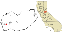
 Location in El Dorado County and the state of California |
|
| Location in the United States | |
| Coordinates: 38°39′57″N 120°55′34″W / 38.66583°N 120.92611°WCoordinates: 38°39′57″N 120°55′34″W / 38.66583°N 120.92611°W | |
| Country |
|
| State |
|
| County | El Dorado |
| Area | |
| • Total | 8.238 sq mi (21.335 km2) |
| • Land | 8.209 sq mi (21.260 km2) |
| • Water | 0.029 sq mi (0.075 km2) 0.35% |
| Elevation | 1,421 ft (433 m) |
| Population (2010) | |
| • Total | 4,432 |
| • Density | 540/sq mi (210/km2) |
| Time zone | Pacific (PST) (UTC-8) |
| • Summer (DST) | PDT (UTC-7) |
| ZIP code | 95682 |
| Area code(s) | 530 |
| FIPS code | 06-71554 |
| GNIS feature ID | 1659645 |
|
U.S. Geological Survey Geographic Names Information System: Shingle Springs, California |
|
| Reference no. | 456 |
U.S. Geological Survey Geographic Names Information System: Shingle Springs, California
Shingle Springs (formerly, Shingle Spring and Shingle) is a census-designated place (CDP) in El Dorado County, California, United States. The population was 4,432 at the 2010 census, up from 2,643 at the 2000 census. It is located about 40 miles from Sacramento in the historic Gold Country foothills and sits directly on Highway 50. The historic towns of Coloma and Placerville are less than 15 miles away.
Shingle Springs is part of the Sacramento–Arden-Arcade–Roseville Metropolitan Statistical Area.
The Shingle Springs Band of Miwok Indians, a federally recognized tribe of Maidu and Miwok people, are headquartered in Shingle Springs.
Like many of the other towns in California's Mother Lode, Shingle Springs grew on the site of a mining camp set up by gold miners during the California Gold Rush, in this case a group of "49ers" who had followed the Carson-Emigrant Trail through Pleasant Valley, Nevada. It took its name from a horse-drawn shingle machine capable of producing 16,000 shingles a day that was located near the springs at the western edge of the camp. The Boston-Newton Joint Stock Association, which left Boston April 16, 1849, camped there the night before their arrival at Sutter's Fort on September 27, after a remarkable journey across the continent. A rich store of written records preserved by these pioneers has left a detailed picture of the Gold Rush. As a result, the town is now designated California Historical Landmark #456.
...
Wikipedia

