Sherburne, MA
| Sherborn, Massachusetts | ||
|---|---|---|
| Town | ||

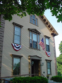
Sherborn Community Center
|
||
|
||
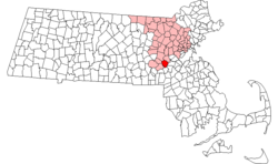
 Location in Middlesex County in Massachusetts |
||
| Coordinates: 42°14′20″N 71°22′13″W / 42.23889°N 71.37028°WCoordinates: 42°14′20″N 71°22′13″W / 42.23889°N 71.37028°W | ||
| Country | United States | |
| State | Massachusetts | |
| County | Middlesex | |
| Settled | 1652 | |
| Incorporated | 1674 | |
| Government | ||
| • Type | Open town meeting | |
| Area | ||
| • Total | 16.2 sq mi (41.9 km2) | |
| • Land | 16.0 sq mi (41.3 km2) | |
| • Water | 0.2 sq mi (0.6 km2) | |
| Elevation | 175 ft (53 m) | |
| Population (2010) | ||
| • Total | 4,119 | |
| • Density | 250/sq mi (98/km2) | |
| Time zone | Eastern (UTC-5) | |
| • Summer (DST) | Eastern (UTC-4) | |
| ZIP code | 01770 | |
| Area code(s) | 508 / 774 | |
| FIPS code | 25-61380 | |
| GNIS feature ID | 0618233 | |
| Website | www.sherbornma.org | |
Sherborn is a town in Middlesex County, Massachusetts, United States. It is in area code 508 and has the ZIP code 01770. As of the 2010 U.S. Census, the town population was 4,119.
Sherborn shares its highly ranked public school system with the town of Dover. In addition to Dover, Sherborn is bordered by the towns of Natick, Framingham, Ashland, Millis, Holliston, and Medfield.
Primarily a farming community until the early part of the 20th century, Sherborn now is a bedroom town for Boston and the surrounding hi-tech area.
Little is known about the local indigenous people. There appear to have been permanent settlements, for the earliest deed of one area refers to the "old fields"; and various implements have been both plowed up and found at Rocky Narrows and near Farm Pond. However, even the name of the tribe is uncertain, for Sherborn seems to have been at the interface between the Massachusetts and the Nipmuck tribes. Several Indians kept land in town after its incorporation (e.g. Peter Ephriam on Brush Hill and Thomas Awussamoag); they appear to have been connected with the Natick "Praying Indian" community.
The whole Charles River valley from South Natick to the falls at Medway kept its Indian name "Boggestow"; it was sought out by the English because of the abundant marsh grass growing on the wide flood plain. The earliest Sherborn land owned by the English took the form of large (200-1074 acres) grants called "farmes" made by the General Court beginning in the 1640s to individuals for payment of services rendered to the colony. These owners later sold land to settlers, the first resale being to Thomas Holbrook, and Nicholas Wood in 1652. They and successive settlers bought those wilderness lands and lived there while retaining their citizenship in the nearest incorporated town: Medfield.
...
Wikipedia

